Tempoal de Sánchez geodata
Tempoal de Sánchez (Veracruz) is a seat of a second-order administrative division; located in Mexico in America/Mexico_City (GMT-6) time zone. With population of 12,526 people, there are 776 cities with bigger population in this country. Compared to other cities in Mexico, 81.5% of cities are located further ↓South; 58.8% of cities are located further ←West and 82.6% of cities have higher elevation than Tempoal de Sánchez. Note1


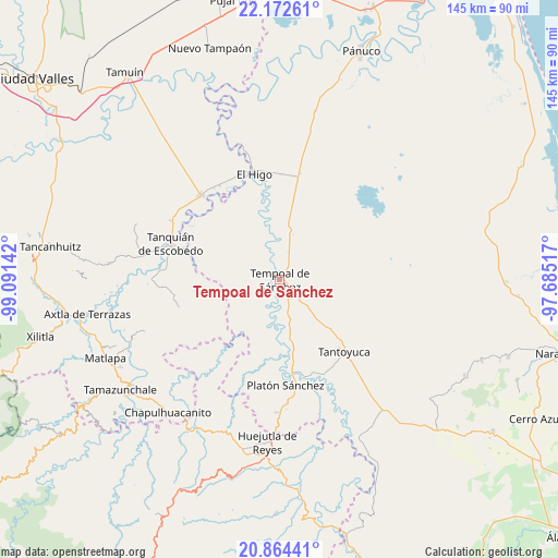
Tempoal de Sánchez GPS coordinates[2]
21° 31' 11.928" North, 98° 23' 17.844" West
| Map corner | latitude | longitude |
|---|---|---|
| Upper-left | 22.17261°, | -99.09142° |
| Center: | 21.51998°, | -98.38829° |
| Lower-right: | 20.86441°, | -97.68517° |
| Map W x H: | 145.5×145.5 km | = 90.4×90.4mi |
| max Lat: | 32.7° ⇑18.5% North |
| Tempoal de Sánchez: | 21.51998° |
| min Lat: | ⇓81.5% South 14.53588° |
| min Long | Tempoal de Sán | max Long |
| -117.105° | -98.38829° | -86.73105° |
| W 58.8%⇐ | ⇒41.2% E |
Elevation
Elevation of Tempoal de Sánchez is 64 m = 210 ft, and this is 1189.7 m = 3903 ft below average elevation for this country.
| Max E: |
3497 m = 11473 ft | 82.6% |
| Avg. | 1253.7 m = 4113 ft | |
| Tempoal de Sánchez | 64 m = 210 ft | |
Min E: |
-1 m = -3 ft | 17.4% |
See also: Mexico elevation on elevation.city.
Geographical zone
Tempoal de Sánchez is located in North Torrid zone (between Equator and Tropic of Cancer). Distance of this Northern Tropic circle is 213.1 km =132.4 mi to North.| Distance of | km | miles | from Tempoal de Sánchez |
|---|---|---|---|
| North Pole | 7614.3 | 4731.3 | to North |
| Arctic Circle | 5008.4 | 3112.1 | to North |
| Tropic Cancer | 213.1 | 132.4 | to North |
| Equator | 2392.8 | 1486.8 | to South |


Nearby cities:
15 places around Tempoal de Sánchez: (largest is in red/bold)
• Ciruelar Aquiche
15 km =9.3 mi,  148°
148°
• Corozal
17.4 km =10.8 mi,  279°
279°
• Cruz de Palma
11 km =6.8 mi,  87°
87°
• Cuchilla Chica
14.1 km =8.8 mi,  138°
138°
• El Aguacate Terrero
12.1 km =7.5 mi,  199°
199°
• El Jobo Aquiche
17 km =10.6 mi, 148°
• El Rincón
12.6 km =7.8 mi,  134°
134°
• La Estanzuela
16.1 km =10 mi, 138°
• La Peña
13.6 km =8.5 mi, 142°
• Las Mesas San Gabriel (Las Mesas)
14.3 km =8.9 mi,  172°
172°
• Palmar Aquiche Primero
17 km =10.6 mi, 143°
• Placetas
16.4 km =10.2 mi,  117°
117°
• Potrero Horcón
14.1 km =8.8 mi,  47°
47°
• Rancho Nuevo
16.2 km =10.1 mi, 134°
• Terrero
13.3 km =8.3 mi, 121°
Sources, notices
• [Note1] Compared only with cities in Mexico existing in our database
• [Src1] Map data: © OpenStreetMap contributors (CC-BY-SA)
• [Src2] Other city data from geonames.org with taken over terms of usage.
• [Src3] Geographical zone / Annual Mean Temperature by Robert A. Rohde @ Wikipedia
