Cruz de Palma geodata
Cruz de Palma (Veracruz) is a populated place; located in Mexico in America/Mexico_City (GMT-6) time zone. With population of 719 people, there are 12132 cities with bigger population in this country. Compared to other cities in Mexico, 81.6% of cities are located further ↓South; 60.1% of cities are located further ←West and 77.7% of cities have higher elevation than Cruz de Palma. Note1


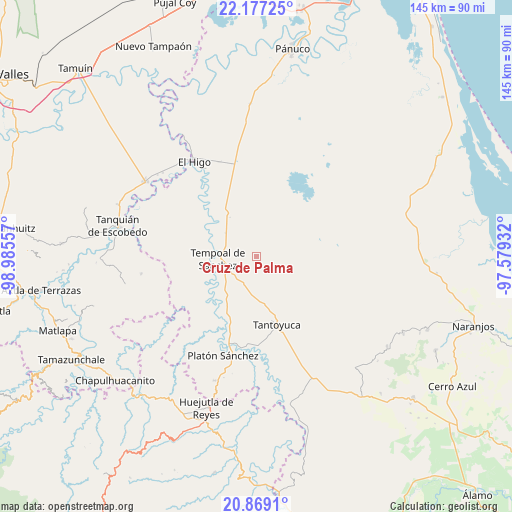
Cruz de Palma GPS coordinates[2]
21° 31' 28.74" North, 98° 16' 56.784" West
| Map corner | latitude | longitude |
|---|---|---|
| Upper-left | 22.17725°, | -98.98557° |
| Center: | 21.52465°, | -98.28244° |
| Lower-right: | 20.8691°, | -97.57932° |
| Map W x H: | 145.5×145.5 km | = 90.4×90.4mi |
| max Lat: | 32.7° ⇑18.4% North |
| Cruz de Palma: | 21.52465° |
| min Lat: | ⇓81.6% South 14.53588° |
| min Long | Cruz de Palma | max Long |
| -117.105° | -98.28244° | -86.73105° |
| W 60.1%⇐ | ⇒39.9% E |
Elevation
Elevation of Cruz de Palma is 138 m = 453 ft, and this is 1115.7 m = 3660 ft below average elevation for this country.
| Max E: |
3497 m = 11473 ft | 77.7% |
| Avg. | 1253.7 m = 4113 ft | |
| Cruz de Palma | 138 m = 453 ft | |
Min E: |
-1 m = -3 ft | 22.3% |
See also: Mexico elevation on elevation.city.
Geographical zone
Cruz de Palma is located in North Torrid zone (between Equator and Tropic of Cancer). Distance of this Northern Tropic circle is 212.6 km =132.1 mi to North.| Distance of | km | miles | from Cruz de Palma |
|---|---|---|---|
| North Pole | 7613.7 | 4730.9 | to North |
| Arctic Circle | 5007.9 | 3111.8 | to North |
| Tropic Cancer | 212.6 | 132.1 | to North |
| Equator | 2393.3 | 1487.1 | to South |


Nearby cities:
15 places around Cruz de Palma: (largest is in red/bold)
• Cerro Botica
12.7 km =7.9 mi,  172°
172°
• Ciruelar Aquiche
13.7 km =8.5 mi,  193°
193°
• Cuchilla Chica
11.2 km =7 mi, 188°
• El Jobo Aquiche
15.1 km =9.4 mi, 187°
• El Rincón
9.6 km =6 mi, 192°
• La Estanzuela
12.6 km =7.8 mi,  181°
181°
• La Peña
11.7 km =7.3 mi, 193°
• Mezquite Mata del Tigre
14.4 km =8.9 mi,  157°
157°
• Palma Alta
11.5 km =7.1 mi,  150°
150°
• Palmar Aquiche Primero
14.2 km =8.8 mi, 183°
• Placetas
8.8 km =5.5 mi, 156°
• Potrero Horcón
9.1 km =5.7 mi,  356°
356°
• Rancho Nuevo
11.9 km =7.4 mi, 176°
• Tempoal de Sánchez
11 km =6.8 mi,  267°
267°
• Terrero
7.6 km =4.7 mi, 177°
Sources, notices
• [Note1] Compared only with cities in Mexico existing in our database
• [Src1] Map data: © OpenStreetMap contributors (CC-BY-SA)
• [Src2] Other city data from geonames.org with taken over terms of usage.
• [Src3] Geographical zone / Annual Mean Temperature by Robert A. Rohde @ Wikipedia
