Venustiano Carranza geodata
Venustiano Carranza (Veracruz) is a populated place; located in Mexico in America/Mexico_City (GMT-6) time zone. With population of 577 people, there are 14851 cities with bigger population in this country. Compared to other cities in Mexico, 73.7% of cities are located further ↓South; 66.9% of cities are located further ←West and 82.7% of cities have higher elevation than Venustiano Carranza. Note1


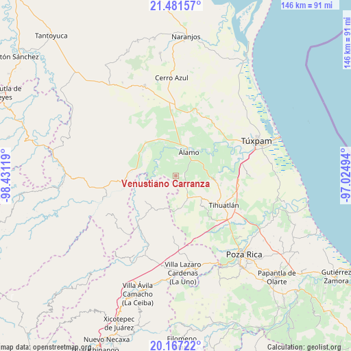
Venustiano Carranza GPS coordinates[2]
20° 49' 32.988" North, 97° 43' 41.016" West
| Map corner | latitude | longitude |
|---|---|---|
| Upper-left | 21.48157°, | -98.43119° |
| Center: | 20.82583°, | -97.72806° |
| Lower-right: | 20.16722°, | -97.02494° |
| Map W x H: | 146.1×146.1 km | = 90.8×90.8mi |
| max Lat: | 32.7° ⇑26.3% North |
| Venustiano Carranza: | 20.82583° |
| min Lat: | ⇓73.7% South 14.53588° |
| min Long | Venustiano Carr | max Long |
| -117.105° | -97.72806° | -86.73105° |
| W 66.9%⇐ | ⇒33.1% E |
Elevation
Elevation of Venustiano Carranza is 63 m = 207 ft, and this is 1190.7 m = 3906 ft below average elevation for this country.
| Max E: |
3497 m = 11473 ft | 82.7% |
| Avg. | 1253.7 m = 4113 ft | |
| Venustiano Carranza | 63 m = 207 ft | |
Min E: |
-1 m = -3 ft | 17.3% |
See also: Mexico elevation on elevation.city.
Geographical zone
Venustiano Carranza is located in North Torrid zone (between Equator and Tropic of Cancer). Distance of this Northern Tropic circle is 290.3 km =180.4 mi to North.| Distance of | km | miles | from Venustiano Carranza |
|---|---|---|---|
| North Pole | 7691.4 | 4779.2 | to North |
| Arctic Circle | 5085.6 | 3160 | to North |
| Tropic Cancer | 290.3 | 180.4 | to North |
| Equator | 2315.6 | 1438.8 | to South |


Nearby cities:
15 places around Venustiano Carranza: (largest is in red/bold)
• Agua Nacida
10.1 km =6.3 mi,  12°
12°
• Aquiles Serdán
4.6 km =2.9 mi,  69°
69°
• El Bejucal
7.6 km =4.7 mi,  107°
107°
• El Tecomate
7.6 km =4.7 mi,  216°
216°
• Emiliano Zapata
4.3 km =2.7 mi, 11°
• La Camelia
9.1 km =5.7 mi,  329°
329°
• La Concepción
6.5 km =4 mi,  49°
49°
• La Providencia
4.1 km =2.5 mi,  63°
63°
• La Reforma
8.7 km =5.4 mi, 59°
• La Unión
9.9 km =6.2 mi,  41°
41°
• Mequetla
5.4 km =3.4 mi,  130°
130°
• Palma Real de Adentro
3.1 km =1.9 mi,  182°
182°
• Paso del Perro
6.9 km =4.3 mi,  288°
288°
• Rodríguez Clara
6.9 km =4.3 mi,  357°
357°
• Tincontlán
3.9 km =2.4 mi,  97°
97°
Sources, notices
• [Note1] Compared only with cities in Mexico existing in our database
• [Src1] Map data: © OpenStreetMap contributors (CC-BY-SA)
• [Src2] Other city data from geonames.org with taken over terms of usage.
• [Src3] Geographical zone / Annual Mean Temperature by Robert A. Rohde @ Wikipedia
