Santa Teresa geodata
Santa Teresa (State of Mexico) is a populated place; located in Mexico in America/Mexico_City (GMT-6) time zone. With population of 36,845 people, there are 279 cities with bigger population in this country. Compared to other cities in Mexico, 53.9% of cities are located further ↓South; 53.4% of cities are located further →East and 86.2% of cities have lower elevation than Santa Teresa. Note1


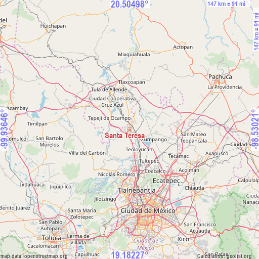
Santa Teresa GPS coordinates[2]
19° 50' 42" North, 99° 13' 59.988" West
| Map corner | latitude | longitude |
|---|---|---|
| Upper-left | 20.50498°, | -99.93646° |
| Center: | 19.845°, | -99.23333° |
| Lower-right: | 19.18227°, | -98.53021° |
| Map W x H: | 147.1×147.1 km | = 91.4×91.4mi |
| max Lat: | 32.7° ⇑46.1% North |
| Santa Teresa: | 19.845° |
| min Lat: | ⇓53.9% South 14.53588° |
| min Long | Santa Teresa | max Long |
| -117.105° | -99.23333° | -86.73105° |
| W 46.6%⇐ | ⇒53.4% E |
Elevation
Elevation of Santa Teresa is 2286 m = 7500 ft, and this is 1032.3 m = 3387 ft above average elevation for this country.
| Max E: |
3497 m = 11473 ft | 13.8% |
| Santa Teresa | 2286 m 7500 ft | |
| Avg. | 1253.7 m = 4113 ft | |
Min E: |
-1 m = -3 ft | 86.2% |
See also: Mexico elevation on elevation.city.
Geographical zone
Santa Teresa is located in North Torrid zone (between Equator and Tropic of Cancer). Distance of this Northern Tropic circle is 399.4 km =248.2 mi to North.| Distance of | km | miles | from Santa Teresa |
|---|---|---|---|
| North Pole | 7800.5 | 4847 | to North |
| Arctic Circle | 5194.6 | 3227.8 | to North |
| Tropic Cancer | 399.4 | 248.2 | to North |
| Equator | 2206.6 | 1371.1 | to South |


Nearby cities:
15 places around Santa Teresa: (largest is in red/bold)
• Barranca Prieta
2.4 km =1.5 mi,  61°
61°
• Casa Nueva
2.8 km =1.7 mi,  117°
117°
• Coyotepec
7.8 km =4.8 mi,  164°
164°
• Ex-hacienda de Xalpa
5.9 km =3.7 mi, 116°
• Huehuetoca
3.6 km =2.2 mi, 121°
• Jorobas
2.8 km =1.7 mi,  213°
213°
• Paseos de la Pradera
5.2 km =3.2 mi,  354°
354°
• Praderas del Potrero
4.4 km =2.7 mi,  4°
4°
• Salitrillo
2.5 km =1.6 mi,  133°
133°
• San Bartolo
4.5 km =2.8 mi,  107°
107°
• San Pedro Xalpa
5.5 km =3.4 mi, 111°
• Santiago Tlaltepoxco
5.1 km =3.2 mi,  326°
326°
• Segunda Sección del Barrio de Santiago
7.9 km =4.9 mi,  175°
175°
• Unidad San Miguel Jagüeyes
6.3 km =3.9 mi,  247°
247°
• Villa URBI del Rey
2.5 km =1.6 mi,  260°
260°
Sources, notices
• [Note1] Compared only with cities in Mexico existing in our database
• [Src1] Map data: © OpenStreetMap contributors (CC-BY-SA)
• [Src2] Other city data from geonames.org with taken over terms of usage.
• [Src3] Geographical zone / Annual Mean Temperature by Robert A. Rohde @ Wikipedia
