Guadalupe Victoria geodata
Guadalupe Victoria (Veracruz) is a populated place; located in Mexico in America/Mexico_City (GMT-6) time zone. With population of 6,114 people, there are 1530 cities with bigger population in this country. Compared to other cities in Mexico, 53% of cities are located further ↑North; 75.4% of cities are located further ←West and 50.5% of cities have lower elevation than Guadalupe Victoria. Note1


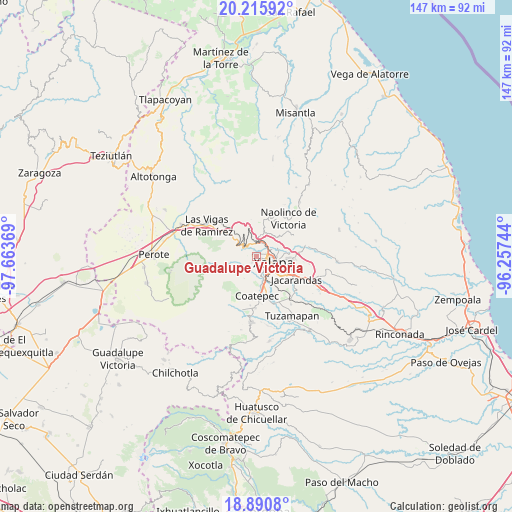
Guadalupe Victoria GPS coordinates[2]
19° 33' 16.992" North, 96° 57' 38.016" West
| Map corner | latitude | longitude |
|---|---|---|
| Upper-left | 20.21592°, | -97.66369° |
| Center: | 19.55472°, | -96.96056° |
| Lower-right: | 18.8908°, | -96.25744° |
| Map W x H: | 147.3×147.3 km | = 91.5×91.5mi |
| max Lat: | 32.7° ⇑53% North |
| Guadalupe Victoria: | 19.55472° |
| min Lat: | ⇓47% South 14.53588° |
| min Long | Guadalupe Victo | max Long |
| -117.105° | -96.96056° | -86.73105° |
| W 75.4%⇐ | ⇒24.6% E |
Elevation
Elevation of Guadalupe Victoria is 1457 m = 4780 ft, and this is 203.3 m = 667 ft above average elevation for this country.
| Max E: |
3497 m = 11473 ft | 49.5% |
| Guadalupe Victoria | 1457 m 4780 ft | |
| Avg. | 1253.7 m = 4113 ft | |
Min E: |
-1 m = -3 ft | 50.5% |
See also: Mexico elevation on elevation.city.
Geographical zone
Guadalupe Victoria is located in North Torrid zone (between Equator and Tropic of Cancer). Distance of this Northern Tropic circle is 431.6 km =268.2 mi to North.| Distance of | km | miles | from Guadalupe Victoria |
|---|---|---|---|
| North Pole | 7832.8 | 4867.1 | to North |
| Arctic Circle | 5226.9 | 3247.8 | to North |
| Tropic Cancer | 431.6 | 268.2 | to North |
| Equator | 2174.3 | 1351 | to South |


Nearby cities:
15 places around Guadalupe Victoria: (largest is in red/bold)
• Banderilla
4.5 km =2.8 mi,  32°
32°
• Carolino Anaya (Espina Blanca)
0.7 km =0.4 mi,  285°
285°
• Cañada Larga
2.4 km =1.5 mi,  225°
225°
• El Rosario
4 km =2.5 mi,  347°
347°
• Naranjillos
1.9 km =1.2 mi,  241°
241°
• Otilpan
1.7 km =1.1 mi,  279°
279°
• Piedra de Agua
5.5 km =3.4 mi,  357°
357°
• Piletas
4.2 km =2.6 mi,  332°
332°
• Potrero del Bordo (Santa María)
2.3 km =1.4 mi,  216°
216°
• Rafael Lucio
5.3 km =3.3 mi,  323°
323°
• Rancho Viejo
3.6 km =2.2 mi,  210°
210°
• San Antonio Hidalgo
1.9 km =1.2 mi, 220°
• Tlalnelhuayocan
2.1 km =1.3 mi,  310°
310°
• Xalapa de Enríquez
5.4 km =3.4 mi,  119°
119°
• Xaltepec
5.8 km =3.6 mi, 30°
Sources, notices
• [Note1] Compared only with cities in Mexico existing in our database
• [Src1] Map data: © OpenStreetMap contributors (CC-BY-SA)
• [Src2] Other city data from geonames.org with taken over terms of usage.
• [Src3] Geographical zone / Annual Mean Temperature by Robert A. Rohde @ Wikipedia
