San Antonio Hidalgo geodata
San Antonio Hidalgo (Veracruz) is a populated place; located in Mexico in America/Mexico_City (GMT-6) time zone. With population of 936 people, there are 9311 cities with bigger population in this country. Compared to other cities in Mexico, 53.2% of cities are located further ↑North; 75.2% of cities are located further ←West and 50.2% of cities have lower elevation than San Antonio Hidalgo. Note1


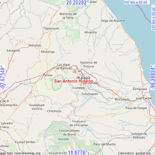
San Antonio Hidalgo GPS coordinates[2]
19° 32' 29.652" North, 96° 58' 20.496" West
| Map corner | latitude | longitude |
|---|---|---|
| Upper-left | 20.20282°, | -97.67549° |
| Center: | 19.54157°, | -96.97236° |
| Lower-right: | 18.8776°, | -96.26924° |
| Map W x H: | 147.4×147.4 km | = 91.6×91.6mi |
| max Lat: | 32.7° ⇑53.2% North |
| San Antonio Hidalgo: | 19.54157° |
| min Lat: | ⇓46.8% South 14.53588° |
| min Long | San Antonio Hid | max Long |
| -117.105° | -96.97236° | -86.73105° |
| W 75.2%⇐ | ⇒24.8% E |
Elevation
Elevation of San Antonio Hidalgo is 1442 m = 4731 ft, and this is 188.3 m = 618 ft above average elevation for this country.
| Max E: |
3497 m = 11473 ft | 49.8% |
| San Antonio Hidalgo | 1442 m 4731 ft | |
| Avg. | 1253.7 m = 4113 ft | |
Min E: |
-1 m = -3 ft | 50.2% |
See also: Mexico elevation on elevation.city.
Geographical zone
San Antonio Hidalgo is located in North Torrid zone (between Equator and Tropic of Cancer). Distance of this Northern Tropic circle is 433.1 km =269.1 mi to North.| Distance of | km | miles | from San Antonio Hidalgo |
|---|---|---|---|
| North Pole | 7834.2 | 4867.9 | to North |
| Arctic Circle | 5228.4 | 3248.8 | to North |
| Tropic Cancer | 433.1 | 269.1 | to North |
| Equator | 2172.8 | 1350.1 | to South |


Nearby cities:
15 places around San Antonio Hidalgo: (largest is in red/bold)
• Carolino Anaya (Espina Blanca)
1.7 km =1.1 mi,  19°
19°
• Cañada Larga
0.5 km =0.3 mi,  243°
243°
• Cinco Palos
5.1 km =3.2 mi,  200°
200°
• Cuauhtémoc
5.5 km =3.4 mi,  185°
185°
• El Rosario
5.3 km =3.3 mi,  3°
3°
• Guadalupe Victoria
1.9 km =1.2 mi,  40°
40°
• Mariano Escobedo
5.7 km =3.5 mi,  149°
149°
• Mazatepec
6 km =3.7 mi,  306°
306°
• Naranjillos
0.7 km =0.4 mi,  319°
319°
• Otilpan
1.8 km =1.1 mi,  345°
345°
• Piletas
5.2 km =3.2 mi, 352°
• Potrero del Bordo (Santa María)
0.5 km =0.3 mi, 200°
• Rancho Viejo
1.7 km =1.1 mi, 200°
• Tlalnelhuayocan
2.8 km =1.7 mi, 353°
• Xalapa de Enríquez
6 km =3.7 mi,  100°
100°
Sources, notices
• [Note1] Compared only with cities in Mexico existing in our database
• [Src1] Map data: © OpenStreetMap contributors (CC-BY-SA)
• [Src2] Other city data from geonames.org with taken over terms of usage.
• [Src3] Geographical zone / Annual Mean Temperature by Robert A. Rohde @ Wikipedia
