Banderilla geodata
Banderilla (Veracruz) is a seat of a second-order administrative division; located in Mexico in America/Mexico_City (GMT-6) time zone. With population of 19,649 people, there are 508 cities with bigger population in this country. Compared to other cities in Mexico, 52.1% of cities are located further ↑North; 75.7% of cities are located further ←West and 51.4% of cities have lower elevation than Banderilla. Note1


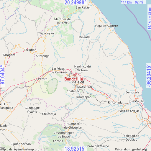
Banderilla GPS coordinates[2]
19° 35' 20.148" North, 96° 56' 14.172" West
| Map corner | latitude | longitude |
|---|---|---|
| Upper-left | 20.24998°, | -97.6404° |
| Center: | 19.58893°, | -96.93727° |
| Lower-right: | 18.92515°, | -96.23415° |
| Map W x H: | 147.3×147.3 km | = 91.5×91.5mi |
| max Lat: | 32.7° ⇑52.1% North |
| Banderilla: | 19.58893° |
| min Lat: | ⇓47.9% South 14.53588° |
| min Long | Banderilla | max Long |
| -117.105° | -96.93727° | -86.73105° |
| W 75.7%⇐ | ⇒24.3% E |
Elevation
Elevation of Banderilla is 1500 m = 4921 ft, and this is 246.3 m = 808 ft above average elevation for this country.
| Max E: |
3497 m = 11473 ft | 48.6% |
| Banderilla | 1500 m 4921 ft | |
| Avg. | 1253.7 m = 4113 ft | |
Min E: |
-1 m = -3 ft | 51.4% |
See also: Mexico elevation on elevation.city.
Geographical zone
Banderilla is located in North Torrid zone (between Equator and Tropic of Cancer). Distance of this Northern Tropic circle is 427.8 km =265.8 mi to North.| Distance of | km | miles | from Banderilla |
|---|---|---|---|
| North Pole | 7829 | 4864.7 | to North |
| Arctic Circle | 5223.1 | 3245.5 | to North |
| Tropic Cancer | 427.8 | 265.8 | to North |
| Equator | 2178.1 | 1353.4 | to South |


Nearby cities:
15 places around Banderilla: (largest is in red/bold)
• Carolino Anaya (Espina Blanca)
4.8 km =3 mi,  220°
220°
• El Pueblito (Garbanzal)
1.5 km =0.9 mi,  68°
68°
• El Rosario
3.3 km =2.1 mi,  270°
270°
• Guadalupe Victoria
4.5 km =2.8 mi,  212°
212°
• Jilotepec
3 km =1.9 mi,  329°
329°
• La Concepción
4.3 km =2.7 mi,  63°
63°
• La Haciendita
3.8 km =2.4 mi,  116°
116°
• Las Lomas
4.7 km =2.9 mi,  35°
35°
• Linderos
5.2 km =3.2 mi,  317°
317°
• Otilpan
5.4 km =3.4 mi,  229°
229°
• Piedra de Agua
3.2 km =2 mi,  301°
301°
• Piletas
4.3 km =2.7 mi, 268°
• Rafael Lucio
5.6 km =3.5 mi, 274°
• Tlalnelhuayocan
4.7 km =2.9 mi,  238°
238°
• Xaltepec
1.3 km =0.8 mi,  22°
22°
Sources, notices
• [Note1] Compared only with cities in Mexico existing in our database
• [Src1] Map data: © OpenStreetMap contributors (CC-BY-SA)
• [Src2] Other city data from geonames.org with taken over terms of usage.
• [Src3] Geographical zone / Annual Mean Temperature by Robert A. Rohde @ Wikipedia
