Xaltepec geodata
Xaltepec (Veracruz) is a populated place; located in Mexico in America/Mexico_City (GMT-6) time zone. With population of 933 people, there are 9344 cities with bigger population in this country. Compared to other cities in Mexico, 51.9% of cities are located further ↑North; 75.8% of cities are located further ←West and 53.6% of cities have lower elevation than Xaltepec. Note1


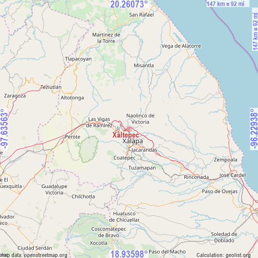
Xaltepec GPS coordinates[2]
19° 35' 58.992" North, 96° 55' 57" West
| Map corner | latitude | longitude |
|---|---|---|
| Upper-left | 20.26073°, | -97.63563° |
| Center: | 19.59972°, | -96.9325° |
| Lower-right: | 18.93598°, | -96.22938° |
| Map W x H: | 147.3×147.3 km | = 91.5×91.5mi |
| max Lat: | 32.7° ⇑51.9% North |
| Xaltepec: | 19.59972° |
| min Lat: | ⇓48.1% South 14.53588° |
| min Long | Xaltepec | max Long |
| -117.105° | -96.9325° | -86.73105° |
| W 75.8%⇐ | ⇒24.2% E |
Elevation
Elevation of Xaltepec is 1552 m = 5092 ft, and this is 298.3 m = 979 ft above average elevation for this country.
| Max E: |
3497 m = 11473 ft | 46.4% |
| Xaltepec | 1552 m 5092 ft | |
| Avg. | 1253.7 m = 4113 ft | |
Min E: |
-1 m = -3 ft | 53.6% |
See also: Mexico elevation on elevation.city.
Geographical zone
Xaltepec is located in North Torrid zone (between Equator and Tropic of Cancer). Distance of this Northern Tropic circle is 426.6 km =265.1 mi to North.| Distance of | km | miles | from Xaltepec |
|---|---|---|---|
| North Pole | 7827.8 | 4864 | to North |
| Arctic Circle | 5221.9 | 3244.7 | to North |
| Tropic Cancer | 426.6 | 265.1 | to North |
| Equator | 2179.3 | 1354.2 | to South |


Nearby cities:
15 places around Xaltepec: (largest is in red/bold)
• Banderilla
1.3 km =0.8 mi,  202°
202°
• Carolino Anaya (Espina Blanca)
6 km =3.7 mi,  216°
216°
• Coacoatzintla
5.8 km =3.6 mi,  351°
351°
• El Pueblito (Garbanzal)
1.1 km =0.7 mi,  126°
126°
• El Rosario
4 km =2.5 mi,  253°
253°
• Guadalupe Victoria
5.8 km =3.6 mi,  210°
210°
• Jilotepec
2.4 km =1.5 mi,  303°
303°
• La Concepción
3.5 km =2.2 mi,  77°
77°
• La Haciendita
4.1 km =2.5 mi,  135°
135°
• Las Lomas
3.4 km =2.1 mi,  40°
40°
• Linderos
4.8 km =3 mi, 303°
• Piedra de Agua
3.2 km =2 mi,  278°
278°
• Piletas
5 km =3.1 mi, 254°
• Rafael Lucio
6.1 km =3.8 mi,  263°
263°
• Tlalnelhuayocan
5.8 km =3.6 mi,  230°
230°
Sources, notices
• [Note1] Compared only with cities in Mexico existing in our database
• [Src1] Map data: © OpenStreetMap contributors (CC-BY-SA)
• [Src2] Other city data from geonames.org with taken over terms of usage.
• [Src3] Geographical zone / Annual Mean Temperature by Robert A. Rohde @ Wikipedia
