Pocitos geodata
Pocitos (Aguascalientes) is a populated place; located in Mexico in America/Mexico_City (GMT-6) time zone. With population of 5,169 people, there are 1795 cities with bigger population in this country. Compared to other cities in Mexico, 83.6% of cities are located further ↓South; 83.1% of cities are located further →East and 66.5% of cities have lower elevation than Pocitos. Note1


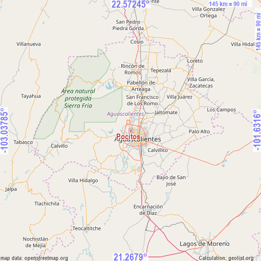
Pocitos GPS coordinates[2]
21° 55' 18.012" North, 102° 20' 4.992" West
| Map corner | latitude | longitude |
|---|---|---|
| Upper-left | 22.57245°, | -103.03785° |
| Center: | 21.92167°, | -102.33472° |
| Lower-right: | 21.2679°, | -101.6316° |
| Map W x H: | 145.1×145.1 km | = 90.2×90.2mi |
| max Lat: | 32.7° ⇑16.4% North |
| Pocitos: | 21.92167° |
| min Lat: | ⇓83.6% South 14.53588° |
| min Long | Pocitos | max Long |
| -117.105° | -102.33472° | -86.73105° |
| W 16.9%⇐ | ⇒83.1% E |
Elevation
Elevation of Pocitos is 1861 m = 6106 ft, and this is 607.3 m = 1992 ft above average elevation for this country.
| Max E: |
3497 m = 11473 ft | 33.5% |
| Pocitos | 1861 m 6106 ft | |
| Avg. | 1253.7 m = 4113 ft | |
Min E: |
-1 m = -3 ft | 66.5% |
See also: Mexico elevation on elevation.city.
Geographical zone
Pocitos is located in North Torrid zone (between Equator and Tropic of Cancer). Distance of this Northern Tropic circle is 168.5 km =104.7 mi to North.| Distance of | km | miles | from Pocitos |
|---|---|---|---|
| North Pole | 7569.6 | 4703.5 | to North |
| Arctic Circle | 4963.7 | 3084.3 | to North |
| Tropic Cancer | 168.5 | 104.7 | to North |
| Equator | 2437.5 | 1514.6 | to South |


Nearby cities:
15 places around Pocitos: (largest is in red/bold)
• Arboledas Paso Blanco [Fraccionamiento]
5.8 km =3.6 mi,  35°
35°
• CERESO (Para Varones y Mujeres)
5.6 km =3.5 mi,  216°
216°
• Corral de Barrancos
3.2 km =2 mi,  4°
4°
• El Llano
2.8 km =1.7 mi,  26°
26°
• Hacienda Nueva
3 km =1.9 mi,  232°
232°
• Jesús María
4.5 km =2.8 mi,  348°
348°
• La Loma de los Negritos
5.9 km =3.7 mi,  195°
195°
• Los Arenales
4.8 km =3 mi,  15°
15°
• Los Arquitos
5.2 km =3.2 mi,  271°
271°
• Los Ramírez
5.6 km =3.5 mi,  10°
10°
• Los Vázquez
5.9 km =3.7 mi, 4°
• Maravillas
3.6 km =2.2 mi, 7°
• Paso Blanco
6.1 km =3.8 mi, 17°
• San Ignacio
3.3 km =2.1 mi,  189°
189°
• Tepetates
4.1 km =2.5 mi, 19°
Sources, notices
• [Note1] Compared only with cities in Mexico existing in our database
• [Src1] Map data: © OpenStreetMap contributors (CC-BY-SA)
• [Src2] Other city data from geonames.org with taken over terms of usage.
• [Src3] Geographical zone / Annual Mean Temperature by Robert A. Rohde @ Wikipedia
