Los Ramírez geodata
Los Ramírez (Aguascalientes) is a populated place; located in Mexico in America/Mexico_City (GMT-6) time zone. With population of 683 people, there are 12712 cities with bigger population in this country. Compared to other cities in Mexico, 84% of cities are located further ↓South; 83% of cities are located further →East and 66.6% of cities have lower elevation than Los Ramírez. Note1


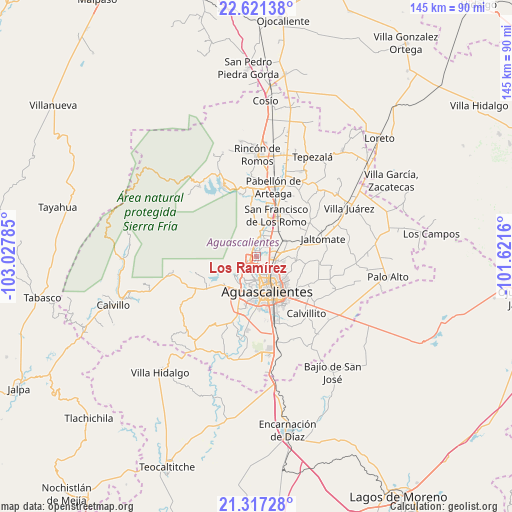
Los Ramírez GPS coordinates[2]
21° 58' 14.988" North, 102° 19' 28.992" West
| Map corner | latitude | longitude |
|---|---|---|
| Upper-left | 22.62138°, | -103.02785° |
| Center: | 21.97083°, | -102.32472° |
| Lower-right: | 21.31728°, | -101.6216° |
| Map W x H: | 145×145 km | = 90.1×90.1mi |
| max Lat: | 32.7° ⇑16% North |
| Los Ramírez: | 21.97083° |
| min Lat: | ⇓84% South 14.53588° |
| min Long | Los Ramírez | max Long |
| -117.105° | -102.32472° | -86.73105° |
| W 17%⇐ | ⇒83% E |
Elevation
Elevation of Los Ramírez is 1862 m = 6109 ft, and this is 608.3 m = 1996 ft above average elevation for this country.
| Max E: |
3497 m = 11473 ft | 33.4% |
| Los Ramírez | 1862 m 6109 ft | |
| Avg. | 1253.7 m = 4113 ft | |
Min E: |
-1 m = -3 ft | 66.6% |
See also: Mexico elevation on elevation.city.
Geographical zone
Los Ramírez is located in North Torrid zone (between Equator and Tropic of Cancer). Distance of this Northern Tropic circle is 163 km =101.3 mi to North.| Distance of | km | miles | from Los Ramírez |
|---|---|---|---|
| North Pole | 7564.1 | 4700.1 | to North |
| Arctic Circle | 4958.2 | 3080.9 | to North |
| Tropic Cancer | 163 | 101.3 | to North |
| Equator | 2442.9 | 1517.9 | to South |


Nearby cities:
15 places around Los Ramírez: (largest is in red/bold)
• Arboledas Paso Blanco [Fraccionamiento]
2.5 km =1.6 mi,  108°
108°
• Corral de Barrancos
2.4 km =1.5 mi,  198°
198°
• El Llano
3 km =1.9 mi,  176°
176°
• Jesús Gómez Portugal
4.5 km =2.8 mi,  51°
51°
• Jesús María
2.2 km =1.4 mi,  240°
240°
• La Florida
2.5 km =1.6 mi,  56°
56°
• Los Arenales
0.9 km =0.6 mi,  161°
161°
• Los Vázquez
0.7 km =0.4 mi,  309°
309°
• Maravillas
1.9 km =1.2 mi, 195°
• Miravalle
1.4 km =0.9 mi,  82°
82°
• Paseos de las Haciendas [Fraccionamiento]
3.1 km =1.9 mi,  320°
320°
• Paso Blanco
0.9 km =0.6 mi,  68°
68°
• San Antonio de los Horcones
3.1 km =1.9 mi,  356°
356°
• Tepetates
1.6 km =1 mi,  168°
168°
• Viñedos Rivier
4.1 km =2.5 mi, 78°
Sources, notices
• [Note1] Compared only with cities in Mexico existing in our database
• [Src1] Map data: © OpenStreetMap contributors (CC-BY-SA)
• [Src2] Other city data from geonames.org with taken over terms of usage.
• [Src3] Geographical zone / Annual Mean Temperature by Robert A. Rohde @ Wikipedia
