El Llano geodata
El Llano (Aguascalientes) is a populated place; located in Mexico in America/Mexico_City (GMT-6) time zone. With population of 2,571 people, there are 3444 cities with bigger population in this country. Compared to other cities in Mexico, 83.8% of cities are located further ↓South; 83% of cities are located further →East and 66.5% of cities have lower elevation than El Llano. Note1


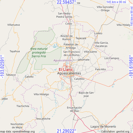
El Llano GPS coordinates[2]
21° 56' 38.004" North, 102° 19' 22.008" West
| Map corner | latitude | longitude |
|---|---|---|
| Upper-left | 22.59457°, | -103.02591° |
| Center: | 21.94389°, | -102.32278° |
| Lower-right: | 21.29022°, | -101.61966° |
| Map W x H: | 145×145 km | = 90.1×90.1mi |
| max Lat: | 32.7° ⇑16.2% North |
| El Llano: | 21.94389° |
| min Lat: | ⇓83.8% South 14.53588° |
| min Long | El Llano | max Long |
| -117.105° | -102.32278° | -86.73105° |
| W 17%⇐ | ⇒83% E |
Elevation
Elevation of El Llano is 1861 m = 6106 ft, and this is 607.3 m = 1992 ft above average elevation for this country.
| Max E: |
3497 m = 11473 ft | 33.5% |
| El Llano | 1861 m 6106 ft | |
| Avg. | 1253.7 m = 4113 ft | |
Min E: |
-1 m = -3 ft | 66.5% |
See also: Mexico elevation on elevation.city.
Geographical zone
El Llano is located in North Torrid zone (between Equator and Tropic of Cancer). Distance of this Northern Tropic circle is 166 km =103.1 mi to North.| Distance of | km | miles | from El Llano |
|---|---|---|---|
| North Pole | 7567.1 | 4702 | to North |
| Arctic Circle | 4961.2 | 3082.7 | to North |
| Tropic Cancer | 166 | 103.1 | to North |
| Equator | 2439.9 | 1516.1 | to South |


Nearby cities:
15 places around El Llano: (largest is in red/bold)
• Arboledas Paso Blanco [Fraccionamiento]
3.1 km =1.9 mi,  44°
44°
• Cartagena [Fraccionamiento]
5 km =3.1 mi,  73°
73°
• Corral de Barrancos
1.2 km =0.7 mi,  306°
306°
• Ex-Viñedos Guadalupe
5.3 km =3.3 mi, 70°
• Jesús María
2.9 km =1.8 mi, 312°
• La Florida
4.7 km =2.9 mi,  23°
23°
• Los Arenales
2.2 km =1.4 mi,  2°
2°
• Los Ramírez
3 km =1.9 mi,  356°
356°
• Los Vázquez
3.5 km =2.2 mi,  348°
348°
• Maravillas
1.3 km =0.8 mi,  327°
327°
• Miravalle
3.4 km =2.1 mi, 20°
• Montebello Della Stanza [Fraccionamiento]
5.3 km =3.3 mi,  99°
99°
• Paso Blanco
3.4 km =2.1 mi,  10°
10°
• Pocitos
2.8 km =1.7 mi,  206°
206°
• Tepetates
1.4 km =0.9 mi, 4°
Sources, notices
• [Note1] Compared only with cities in Mexico existing in our database
• [Src1] Map data: © OpenStreetMap contributors (CC-BY-SA)
• [Src2] Other city data from geonames.org with taken over terms of usage.
• [Src3] Geographical zone / Annual Mean Temperature by Robert A. Rohde @ Wikipedia
