Tepetates geodata
Tepetates (Aguascalientes) is a populated place; located in Mexico in America/Mexico_City (GMT-6) time zone. With population of 1,683 people, there are 5162 cities with bigger population in this country. Compared to other cities in Mexico, 83.9% of cities are located further ↓South; 83% of cities are located further →East and 66.8% of cities have lower elevation than Tepetates. Note1


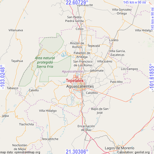
Tepetates GPS coordinates[2]
21° 57' 24.012" North, 102° 19' 18.012" West
| Map corner | latitude | longitude |
|---|---|---|
| Upper-left | 22.60729°, | -103.0248° |
| Center: | 21.95667°, | -102.32167° |
| Lower-right: | 21.30306°, | -101.61855° |
| Map W x H: | 145×145 km | = 90.1×90.1mi |
| max Lat: | 32.7° ⇑16.1% North |
| Tepetates: | 21.95667° |
| min Lat: | ⇓83.9% South 14.53588° |
| min Long | Tepetates | max Long |
| -117.105° | -102.32167° | -86.73105° |
| W 17%⇐ | ⇒83% E |
Elevation
Elevation of Tepetates is 1865 m = 6119 ft, and this is 611.3 m = 2006 ft above average elevation for this country.
| Max E: |
3497 m = 11473 ft | 33.2% |
| Tepetates | 1865 m 6119 ft | |
| Avg. | 1253.7 m = 4113 ft | |
Min E: |
-1 m = -3 ft | 66.8% |
See also: Mexico elevation on elevation.city.
Geographical zone
Tepetates is located in North Torrid zone (between Equator and Tropic of Cancer). Distance of this Northern Tropic circle is 164.6 km =102.3 mi to North.| Distance of | km | miles | from Tepetates |
|---|---|---|---|
| North Pole | 7565.7 | 4701.1 | to North |
| Arctic Circle | 4959.8 | 3081.9 | to North |
| Tropic Cancer | 164.6 | 102.3 | to North |
| Equator | 2441.4 | 1517 | to South |


Nearby cities:
15 places around Tepetates: (largest is in red/bold)
• Arboledas Paso Blanco [Fraccionamiento]
2.2 km =1.4 mi,  69°
69°
• Cartagena [Fraccionamiento]
4.7 km =2.9 mi,  90°
90°
• Corral de Barrancos
1.3 km =0.8 mi,  236°
236°
• El Llano
1.4 km =0.9 mi,  184°
184°
• Jesús María
2.3 km =1.4 mi,  282°
282°
• La Florida
3.4 km =2.1 mi,  31°
31°
• Los Arenales
0.7 km =0.4 mi,  357°
357°
• Los Ramírez
1.6 km =1 mi,  348°
348°
• Los Vázquez
2.2 km =1.4 mi,  337°
337°
• Maravillas
0.9 km =0.6 mi,  251°
251°
• Miravalle
2.1 km =1.3 mi, 31°
• Paseos de las Haciendas [Fraccionamiento]
4.6 km =2.9 mi,  330°
330°
• Paso Blanco
1.9 km =1.2 mi,  14°
14°
• Pocitos
4.1 km =2.5 mi,  199°
199°
• Viñedos Rivier
4.4 km =2.7 mi,  57°
57°
Sources, notices
• [Note1] Compared only with cities in Mexico existing in our database
• [Src1] Map data: © OpenStreetMap contributors (CC-BY-SA)
• [Src2] Other city data from geonames.org with taken over terms of usage.
• [Src3] Geographical zone / Annual Mean Temperature by Robert A. Rohde @ Wikipedia
