Los Arenales geodata
Los Arenales (Aguascalientes) is a populated place; located in Mexico in America/Mexico_City (GMT-6) time zone. With population of 661 people, there are 13143 cities with bigger population in this country. Compared to other cities in Mexico, 83.9% of cities are located further ↓South; 83% of cities are located further →East and 66.8% of cities have lower elevation than Los Arenales. Note1


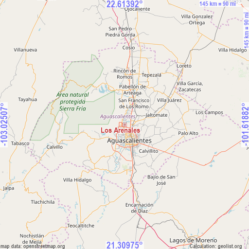
Los Arenales GPS coordinates[2]
21° 57' 47.988" North, 102° 19' 18.984" West
| Map corner | latitude | longitude |
|---|---|---|
| Upper-left | 22.61392°, | -103.02507° |
| Center: | 21.96333°, | -102.32194° |
| Lower-right: | 21.30975°, | -101.61882° |
| Map W x H: | 145×145 km | = 90.1×90.1mi |
| max Lat: | 32.7° ⇑16.1% North |
| Los Arenales: | 21.96333° |
| min Lat: | ⇓83.9% South 14.53588° |
| min Long | Los Arenales | max Long |
| -117.105° | -102.32194° | -86.73105° |
| W 17%⇐ | ⇒83% E |
Elevation
Elevation of Los Arenales is 1866 m = 6122 ft, and this is 612.3 m = 2009 ft above average elevation for this country.
| Max E: |
3497 m = 11473 ft | 33.2% |
| Los Arenales | 1866 m 6122 ft | |
| Avg. | 1253.7 m = 4113 ft | |
Min E: |
-1 m = -3 ft | 66.8% |
See also: Mexico elevation on elevation.city.
Geographical zone
Los Arenales is located in North Torrid zone (between Equator and Tropic of Cancer). Distance of this Northern Tropic circle is 163.8 km =101.8 mi to North.| Distance of | km | miles | from Los Arenales |
|---|---|---|---|
| North Pole | 7565 | 4700.7 | to North |
| Arctic Circle | 4959.1 | 3081.4 | to North |
| Tropic Cancer | 163.8 | 101.8 | to North |
| Equator | 2442.1 | 1517.5 | to South |


Nearby cities:
15 places around Los Arenales: (largest is in red/bold)
• Arboledas Paso Blanco [Fraccionamiento]
2.1 km =1.3 mi,  89°
89°
• Corral de Barrancos
1.8 km =1.1 mi,  216°
216°
• El Llano
2.2 km =1.4 mi,  182°
182°
• Jesús Gómez Portugal
4.8 km =3 mi,  41°
41°
• Jesús María
2.2 km =1.4 mi,  263°
263°
• La Florida
2.8 km =1.7 mi, 39°
• Los Ramírez
0.9 km =0.6 mi,  341°
341°
• Los Vázquez
1.5 km =0.9 mi,  327°
327°
• Maravillas
1.3 km =0.8 mi, 218°
• Miravalle
1.5 km =0.9 mi,  46°
46°
• Paseos de las Haciendas [Fraccionamiento]
3.9 km =2.4 mi, 325°
• Paso Blanco
1.3 km =0.8 mi,  24°
24°
• San Antonio de los Horcones
3.9 km =2.4 mi,  352°
352°
• Tepetates
0.7 km =0.4 mi, 177°
• Viñedos Rivier
4.1 km =2.5 mi,  66°
66°
Sources, notices
• [Note1] Compared only with cities in Mexico existing in our database
• [Src1] Map data: © OpenStreetMap contributors (CC-BY-SA)
• [Src2] Other city data from geonames.org with taken over terms of usage.
• [Src3] Geographical zone / Annual Mean Temperature by Robert A. Rohde @ Wikipedia
