Las Güeras geodata
Las Güeras (Jalisco) is a populated place; located in Mexico in America/Mexico_City (GMT-6) time zone. With population of 576 people, there are 14877 cities with bigger population in this country. Compared to other cities in Mexico, 82.6% of cities are located further ↓South; 81.6% of cities are located further →East and 73.2% of cities have lower elevation than Las Güeras. Note1


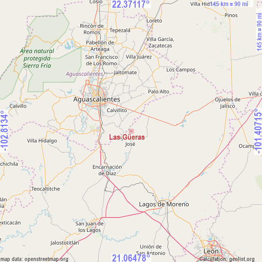
Las Güeras GPS coordinates[2]
21° 43' 10.056" North, 102° 6' 36.972" West
| Map corner | latitude | longitude |
|---|---|---|
| Upper-left | 22.37117°, | -102.8134° |
| Center: | 21.71946°, | -102.11027° |
| Lower-right: | 21.06478°, | -101.40715° |
| Map W x H: | 145.3×145.3 km | = 90.3×90.3mi |
| max Lat: | 32.7° ⇑17.4% North |
| Las Güeras: | 21.71946° |
| min Lat: | ⇓82.6% South 14.53588° |
| min Long | Las Güeras | max Long |
| -117.105° | -102.11027° | -86.73105° |
| W 18.4%⇐ | ⇒81.6% E |
Elevation
Elevation of Las Güeras is 1994 m = 6542 ft, and this is 740.3 m = 2429 ft above average elevation for this country.
| Max E: |
3497 m = 11473 ft | 26.8% |
| Las Güeras | 1994 m 6542 ft | |
| Avg. | 1253.7 m = 4113 ft | |
Min E: |
-1 m = -3 ft | 73.2% |
See also: Mexico elevation on elevation.city.
Geographical zone
Las Güeras is located in North Torrid zone (between Equator and Tropic of Cancer). Distance of this Northern Tropic circle is 190.9 km =118.6 mi to North.| Distance of | km | miles | from Las Güeras |
|---|---|---|---|
| North Pole | 7592.1 | 4717.5 | to North |
| Arctic Circle | 4986.2 | 3098.3 | to North |
| Tropic Cancer | 190.9 | 118.6 | to North |
| Equator | 2415 | 1500.6 | to South |


Nearby cities:
15 places around Las Güeras: (largest is in red/bold)
• Bajío de San José
5 km =3.1 mi,  186°
186°
• Betulia
10.4 km =6.5 mi,  64°
64°
• Cotorina
16.7 km =10.4 mi,  282°
282°
• Cuautitlán
14.7 km =9.1 mi,  82°
82°
• El Puesto
18.3 km =11.4 mi,  125°
125°
• El Refugio de Peñuelas
18.5 km =11.5 mi,  268°
268°
• El Retoño
14.5 km =9 mi,  336°
336°
• El Tecuán
10 km =6.2 mi,  114°
114°
• Matamoros los Hoyos
15.7 km =9.8 mi,  35°
35°
• Mesón de los Sauces
16.4 km =10.2 mi, 190°
• Norias del Paso Hondo
18.7 km =11.6 mi,  327°
327°
• Peñuelas (El Cienegal)
17.1 km =10.6 mi, 271°
• San Cristóbal
18 km =11.2 mi,  103°
103°
• Tacubaya
16.7 km =10.4 mi,  66°
66°
• Villa Licenciado Jesús Terán (Calvillito)
14.2 km =8.8 mi, 325°
Sources, notices
• [Note1] Compared only with cities in Mexico existing in our database
• [Src1] Map data: © OpenStreetMap contributors (CC-BY-SA)
• [Src2] Other city data from geonames.org with taken over terms of usage.
• [Src3] Geographical zone / Annual Mean Temperature by Robert A. Rohde @ Wikipedia
