Las Barrillas geodata
Las Barrillas (Veracruz) is a populated place; located in Mexico in America/Mexico_City (GMT-6) time zone. With population of 1,031 people, there are 8455 cities with bigger population in this country. Compared to other cities in Mexico, 76.4% of cities are located further ↑North; 85.3% of cities are located further ←West and 97.5% of cities have higher elevation than Las Barrillas. Note1


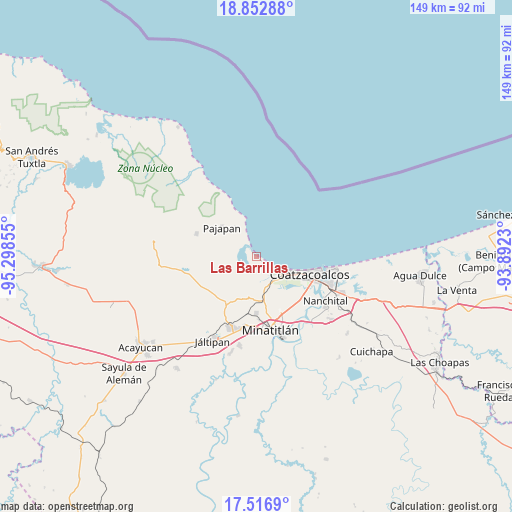
Las Barrillas GPS coordinates[2]
18° 11' 10.212" North, 94° 35' 43.512" West
| Map corner | latitude | longitude |
|---|---|---|
| Upper-left | 18.85288°, | -95.29855° |
| Center: | 18.18617°, | -94.59542° |
| Lower-right: | 17.5169°, | -93.8923° |
| Map W x H: | 148.5×148.5 km | = 92.3×92.3mi |
| max Lat: | 32.7° ⇑76.4% North |
| Las Barrillas: | 18.18617° |
| min Lat: | ⇓23.6% South 14.53588° |
| min Long | Las Barrillas | max Long |
| -117.105° | -94.59542° | -86.73105° |
| W 85.3%⇐ | ⇒14.7% E |
Elevation
Elevation of Las Barrillas is 9 m = 30 ft, and this is 1244.7 m = 4084 ft below average elevation for this country.
| Max E: |
3497 m = 11473 ft | 97.5% |
| Avg. | 1253.7 m = 4113 ft | |
| Las Barrillas | 9 m = 30 ft | |
Min E: |
-1 m = -3 ft | 2.5% |
See also: Mexico elevation on elevation.city.
Geographical zone
Las Barrillas is located in North Torrid zone (between Equator and Tropic of Cancer). Distance of this Northern Tropic circle is 583.8 km =362.8 mi to North.| Distance of | km | miles | from Las Barrillas |
|---|---|---|---|
| North Pole | 7984.9 | 4961.6 | to North |
| Arctic Circle | 5379.1 | 3342.4 | to North |
| Tropic Cancer | 583.8 | 362.8 | to North |
| Equator | 2022.1 | 1256.5 | to South |


Nearby cities:
15 places around Las Barrillas: (largest is in red/bold)
• Barrancas
13 km =8.1 mi,  176°
176°
• Calzadas
17.6 km =10.9 mi,  122°
122°
• Centro de Readaptación Social
9.8 km =6.1 mi, 124°
• Chacalapa
16.5 km =10.3 mi,  223°
223°
• Coatzacoalcos
16.4 km =10.2 mi,  104°
104°
• Fraccionamiento Ciudad Olmeca
6 km =3.7 mi,  131°
131°
• Jicacal
3.6 km =2.2 mi,  329°
329°
• La Guadalupana
9.8 km =6.1 mi, 126°
• Lomas de Barrillas
8.4 km =5.2 mi, 120°
• Los Cerritos
12.1 km =7.5 mi,  190°
190°
• Minzapan
14.9 km =9.3 mi,  249°
249°
• Pajapan
13.3 km =8.3 mi,  309°
309°
• Puerto Esmeralda
9.2 km =5.7 mi, 117°
• Residencial las Olas
8.1 km =5 mi,  157°
157°
• San Juan Volador
10.5 km =6.5 mi, 325°
Sources, notices
• [Note1] Compared only with cities in Mexico existing in our database
• [Src1] Map data: © OpenStreetMap contributors (CC-BY-SA)
• [Src2] Other city data from geonames.org with taken over terms of usage.
• [Src3] Geographical zone / Annual Mean Temperature by Robert A. Rohde @ Wikipedia
