Sector H Tres geodata
Sector H Tres (Oaxaca) is a populated place; located in Mexico in America/Mexico_City (GMT-6) time zone. With population of 2,837 people, there are 3128 cities with bigger population in this country. Compared to other cities in Mexico, 98% of cities are located further ↑North; 81.7% of cities are located further ←West and 81.4% of cities have higher elevation than Sector H Tres. Note1


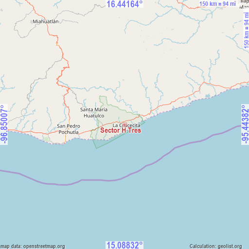
Sector H Tres GPS coordinates[2]
15° 45' 57.996" North, 96° 8' 48.984" West
| Map corner | latitude | longitude |
|---|---|---|
| Upper-left | 16.44164°, | -96.85007° |
| Center: | 15.76611°, | -96.14694° |
| Lower-right: | 15.08832°, | -95.44382° |
| Map W x H: | 150.5×150.5 km | = 93.5×93.5mi |
| max Lat: | 32.7° ⇑98% North |
| Sector H Tres: | 15.76611° |
| min Lat: | ⇓2% South 14.53588° |
| min Long | Sector H Tres | max Long |
| -117.105° | -96.14694° | -86.73105° |
| W 81.7%⇐ | ⇒18.3% E |
Elevation
Elevation of Sector H Tres is 77 m = 253 ft, and this is 1176.7 m = 3861 ft below average elevation for this country.
| Max E: |
3497 m = 11473 ft | 81.4% |
| Avg. | 1253.7 m = 4113 ft | |
| Sector H Tres | 77 m = 253 ft | |
Min E: |
-1 m = -3 ft | 18.6% |
See also: Mexico elevation on elevation.city.
Geographical zone
Sector H Tres is located in North Torrid zone (between Equator and Tropic of Cancer). Distance of this Northern Tropic circle is 852.9 km =530 mi to North.| Distance of | km | miles | from Sector H Tres |
|---|---|---|---|
| North Pole | 8254 | 5128.8 | to North |
| Arctic Circle | 5648.1 | 3509.6 | to North |
| Tropic Cancer | 852.9 | 530 | to North |
| Equator | 1753 | 1089.3 | to South |


Nearby cities:
15 places around Sector H Tres: (largest is in red/bold)
• Aguaje el Zapote
12.1 km =7.5 mi,  269°
269°
• Barra de la Cruz
20.6 km =12.8 mi,  66°
66°
• Benito Juárez
22.9 km =14.2 mi,  304°
304°
• Crucecita
1.3 km =0.8 mi,  76°
76°
• Cuapinolito (Azulillo)
19.4 km =12.1 mi,  288°
288°
• La Erradura
21.5 km =13.4 mi, 290°
• Paso Ancho
20 km =12.4 mi, 295°
• San Felipe Lachilló
27.2 km =16.9 mi,  358°
358°
• San Isidro Apango
23.2 km =14.4 mi,  282°
282°
• San Miguel Figueroa
27.6 km =17.1 mi, 274°
• San Miguel del Puerto
17.6 km =10.9 mi,  350°
350°
• Santa María Huatulco
20 km =12.4 mi, 291°
• Santa María Limón
24.1 km =15 mi, 279°
• Santa María Petatengo
26.3 km =16.3 mi,  30°
30°
• Santa María Xadani
21.7 km =13.5 mi,  21°
21°
Sources, notices
• [Note1] Compared only with cities in Mexico existing in our database
• [Src1] Map data: © OpenStreetMap contributors (CC-BY-SA)
• [Src2] Other city data from geonames.org with taken over terms of usage.
• [Src3] Geographical zone / Annual Mean Temperature by Robert A. Rohde @ Wikipedia
