Paso Ancho geodata
Paso Ancho (Oaxaca) is a populated place; located in Mexico in America/Mexico_City (GMT-6) time zone. With population of 676 people, there are 12846 cities with bigger population in this country. Compared to other cities in Mexico, 97.7% of cities are located further ↑North; 80.8% of cities are located further ←West and 74.4% of cities have higher elevation than Paso Ancho. Note1


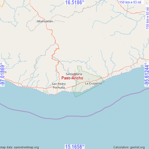
Paso Ancho GPS coordinates[2]
15° 50' 35.988" North, 96° 18' 56.016" West
| Map corner | latitude | longitude |
|---|---|---|
| Upper-left | 16.5186°, | -97.01869° |
| Center: | 15.84333°, | -96.31556° |
| Lower-right: | 15.1658°, | -95.61244° |
| Map W x H: | 150.4×150.4 km | = 93.5×93.5mi |
| max Lat: | 32.7° ⇑97.7% North |
| Paso Ancho: | 15.84333° |
| min Lat: | ⇓2.3% South 14.53588° |
| min Long | Paso Ancho | max Long |
| -117.105° | -96.31556° | -86.73105° |
| W 80.8%⇐ | ⇒19.2% E |
Elevation
Elevation of Paso Ancho is 238 m = 781 ft, and this is 1015.7 m = 3332 ft below average elevation for this country.
| Max E: |
3497 m = 11473 ft | 74.4% |
| Avg. | 1253.7 m = 4113 ft | |
| Paso Ancho | 238 m = 781 ft | |
Min E: |
-1 m = -3 ft | 25.6% |
See also: Mexico elevation on elevation.city.
Geographical zone
Paso Ancho is located in North Torrid zone (between Equator and Tropic of Cancer). Distance of this Northern Tropic circle is 844.3 km =524.6 mi to North.| Distance of | km | miles | from Paso Ancho |
|---|---|---|---|
| North Pole | 8245.4 | 5123.5 | to North |
| Arctic Circle | 5639.6 | 3504.3 | to North |
| Tropic Cancer | 844.3 | 524.6 | to North |
| Equator | 1761.6 | 1094.6 | to South |


Nearby cities:
15 places around Paso Ancho: (largest is in red/bold)
• Aguaje el Zapote
10.4 km =6.5 mi,  145°
145°
• Benito Juárez
4.4 km =2.7 mi,  348°
348°
• Cuapinolito (Azulillo)
2.4 km =1.5 mi,  187°
187°
• La Erradura
2.3 km =1.4 mi,  243°
243°
• Pluma Hidalgo
14.4 km =8.9 mi,  310°
310°
• Reyes
18.6 km =11.6 mi,  260°
260°
• San Isidro Apango
5.9 km =3.7 mi,  230°
230°
• San José Chacalapa
15.9 km =9.9 mi, 264°
• San Mateo Piñas
17.6 km =10.9 mi, 353°
• San Miguel Figueroa
11.4 km =7.1 mi, 236°
• San Miguel del Puerto
17.4 km =10.8 mi,  59°
59°
• San Roque
17 km =10.6 mi,  248°
248°
• Santa María Huatulco
1.3 km =0.8 mi,  204°
204°
• Santa María Limón
7.4 km =4.6 mi, 231°
• Toltepec
15.5 km =9.6 mi,  286°
286°
Sources, notices
• [Note1] Compared only with cities in Mexico existing in our database
• [Src1] Map data: © OpenStreetMap contributors (CC-BY-SA)
• [Src2] Other city data from geonames.org with taken over terms of usage.
• [Src3] Geographical zone / Annual Mean Temperature by Robert A. Rohde @ Wikipedia
