Chiloljá geodata
Chiloljá (Chiapas) is a populated place; located in Mexico in America/Mexico_City (GMT-6) time zone. With population of 2,415 people, there are 3653 cities with bigger population in this country. Compared to other cities in Mexico, 90.5% of cities are located further ↑North; 92.5% of cities are located further ←West and 55.5% of cities have lower elevation than Chiloljá. Note1


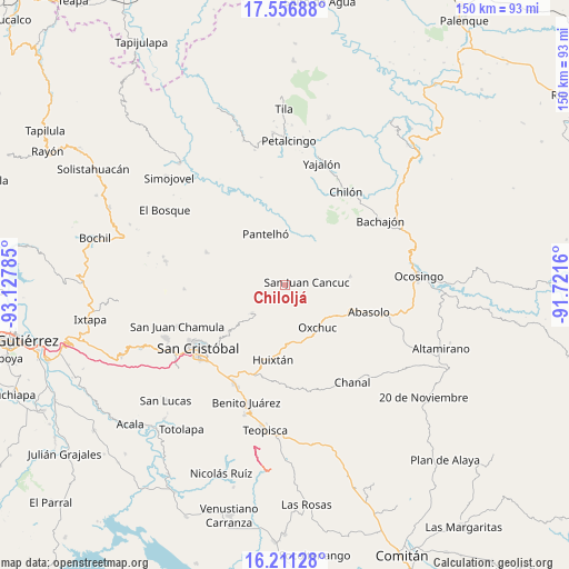
Chiloljá GPS coordinates[2]
16° 53' 7.008" North, 92° 25' 28.992" West
| Map corner | latitude | longitude |
|---|---|---|
| Upper-left | 17.55688°, | -93.12785° |
| Center: | 16.88528°, | -92.42472° |
| Lower-right: | 16.21128°, | -91.7216° |
| Map W x H: | 149.6×149.6 km | = 93×93mi |
| max Lat: | 32.7° ⇑90.5% North |
| Chiloljá: | 16.88528° |
| min Lat: | ⇓9.5% South 14.53588° |
| min Long | Chiloljá | max Long |
| -117.105° | -92.42472° | -86.73105° |
| W 92.5%⇐ | ⇒7.5% E |
Elevation
Elevation of Chiloljá is 1602 m = 5256 ft, and this is 348.3 m = 1143 ft above average elevation for this country.
| Max E: |
3497 m = 11473 ft | 44.5% |
| Chiloljá | 1602 m 5256 ft | |
| Avg. | 1253.7 m = 4113 ft | |
Min E: |
-1 m = -3 ft | 55.5% |
See also: Mexico elevation on elevation.city.
Geographical zone
Chiloljá is located in North Torrid zone (between Equator and Tropic of Cancer). Distance of this Northern Tropic circle is 728.5 km =452.7 mi to North.| Distance of | km | miles | from Chiloljá |
|---|---|---|---|
| North Pole | 8129.6 | 5051.5 | to North |
| Arctic Circle | 5523.7 | 3432.3 | to North |
| Tropic Cancer | 728.5 | 452.7 | to North |
| Equator | 1877.5 | 1166.6 | to South |


Nearby cities:
15 places around Chiloljá: (largest is in red/bold)
• Amaquil (Patio Amplio)
5 km =3.1 mi,  322°
322°
• Chixtontic
3.6 km =2.2 mi,  279°
279°
• Cruz Pilar
3.6 km =2.2 mi,  314°
314°
• El Pozo
4.1 km =2.5 mi,  19°
19°
• Juxalja
4.3 km =2.7 mi,  288°
288°
• Kotolte
4.5 km =2.8 mi,  239°
239°
• La Frontera
5 km =3.1 mi,  148°
148°
• Lelenchij
5.2 km =3.2 mi,  164°
164°
• Nailchén
1.8 km =1.1 mi,  214°
214°
• Sibaniljá Pocolum
4 km =2.5 mi,  255°
255°
• Tz'Aquiviljok
5 km =3.1 mi,  228°
228°
• Tzametal
1.6 km =1 mi, 152°
• Tzuluwitz
2.5 km =1.6 mi,  80°
80°
• Yetzucum
2 km =1.2 mi,  266°
266°
• Yoshib
5 km =3.1 mi, 207°
Sources, notices
• [Note1] Compared only with cities in Mexico existing in our database
• [Src1] Map data: © OpenStreetMap contributors (CC-BY-SA)
• [Src2] Other city data from geonames.org with taken over terms of usage.
• [Src3] Geographical zone / Annual Mean Temperature by Robert A. Rohde @ Wikipedia
