Tzametal geodata
Tzametal (Chiapas) is a populated place; located in Mexico in America/Mexico_City (GMT-6) time zone. With population of 591 people, there are 14530 cities with bigger population in this country. Compared to other cities in Mexico, 90.8% of cities are located further ↑North; 92.6% of cities are located further ←West and 60.4% of cities have lower elevation than Tzametal. Note1


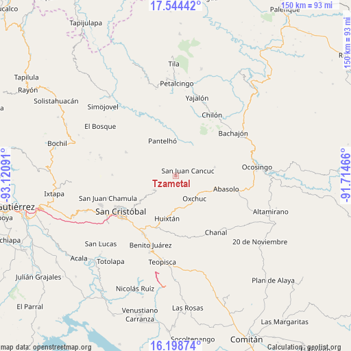
Tzametal GPS coordinates[2]
16° 52' 22.008" North, 92° 25' 4.008" West
| Map corner | latitude | longitude |
|---|---|---|
| Upper-left | 17.54442°, | -93.12091° |
| Center: | 16.87278°, | -92.41778° |
| Lower-right: | 16.19874°, | -91.71466° |
| Map W x H: | 149.6×149.6 km | = 93×93mi |
| max Lat: | 32.7° ⇑90.8% North |
| Tzametal: | 16.87278° |
| min Lat: | ⇓9.2% South 14.53588° |
| min Long | Tzametal | max Long |
| -117.105° | -92.41778° | -86.73105° |
| W 92.6%⇐ | ⇒7.4% E |
Elevation
Elevation of Tzametal is 1733 m = 5686 ft, and this is 479.3 m = 1573 ft above average elevation for this country.
| Max E: |
3497 m = 11473 ft | 39.6% |
| Tzametal | 1733 m 5686 ft | |
| Avg. | 1253.7 m = 4113 ft | |
Min E: |
-1 m = -3 ft | 60.4% |
See also: Mexico elevation on elevation.city.
Geographical zone
Tzametal is located in North Torrid zone (between Equator and Tropic of Cancer). Distance of this Northern Tropic circle is 729.8 km =453.5 mi to North.| Distance of | km | miles | from Tzametal |
|---|---|---|---|
| North Pole | 8131 | 5052.4 | to North |
| Arctic Circle | 5525.1 | 3433.1 | to North |
| Tropic Cancer | 729.8 | 453.5 | to North |
| Equator | 1876.1 | 1165.8 | to South |


Nearby cities:
15 places around Tzametal: (largest is in red/bold)
• Chiloljá
1.6 km =1 mi,  332°
332°
• Chixtontic
4.7 km =2.9 mi,  295°
295°
• Cruz Pilar
5.2 km =3.2 mi,  320°
320°
• El Pozo
5.3 km =3.3 mi,  7°
7°
• Juxalja
5.5 km =3.4 mi, 299°
• Kotolte
4.7 km =2.9 mi,  258°
258°
• La Frontera
3.4 km =2.1 mi,  146°
146°
• Lelenchij
3.7 km =2.3 mi,  169°
169°
• Nailchén
1.7 km =1.1 mi,  267°
267°
• San Juan Cancuc
5.5 km =3.4 mi,  66°
66°
• Sibaniljá Pocolum
4.6 km =2.9 mi, 274°
• Tz'Aquiviljok
4.9 km =3 mi,  246°
246°
• Tzuluwitz
2.5 km =1.6 mi,  44°
44°
• Yetzucum
3 km =1.9 mi,  294°
294°
• Yoshib
4.3 km =2.7 mi,  224°
224°
Sources, notices
• [Note1] Compared only with cities in Mexico existing in our database
• [Src1] Map data: © OpenStreetMap contributors (CC-BY-SA)
• [Src2] Other city data from geonames.org with taken over terms of usage.
• [Src3] Geographical zone / Annual Mean Temperature by Robert A. Rohde @ Wikipedia
