Veinte de Noviembre geodata
Veinte de Noviembre (Chiapas) is a populated place; located in Mexico in America/Mexico_City (GMT-6) time zone. With population of 2,207 people, there are 3977 cities with bigger population in this country. Compared to other cities in Mexico, 93.5% of cities are located further ↑North; 94.9% of cities are located further ←West and 54.1% of cities have lower elevation than Veinte de Noviembre. Note1


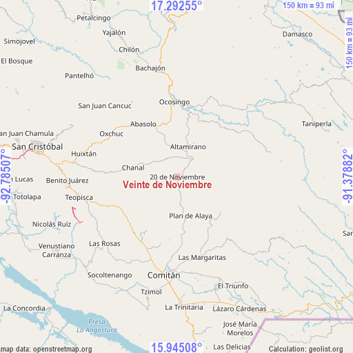
Veinte de Noviembre GPS coordinates[2]
16° 37' 12" North, 92° 4' 54.984" West
| Map corner | latitude | longitude |
|---|---|---|
| Upper-left | 17.29255°, | -92.78507° |
| Center: | 16.62°, | -92.08194° |
| Lower-right: | 15.94508°, | -91.37882° |
| Map W x H: | 149.8×149.8 km | = 93.1×93.1mi |
| max Lat: | 32.7° ⇑93.5% North |
| Veinte de Noviembre: | 16.62° |
| min Lat: | ⇓6.5% South 14.53588° |
| min Long | Veinte de Novie | max Long |
| -117.105° | -92.08194° | -86.73105° |
| W 94.9%⇐ | ⇒5.1% E |
Elevation
Elevation of Veinte de Noviembre is 1565 m = 5135 ft, and this is 311.3 m = 1021 ft above average elevation for this country.
| Max E: |
3497 m = 11473 ft | 45.9% |
| Veinte de Noviembre | 1565 m 5135 ft | |
| Avg. | 1253.7 m = 4113 ft | |
Min E: |
-1 m = -3 ft | 54.1% |
See also: Mexico elevation on elevation.city.
Geographical zone
Veinte de Noviembre is located in North Torrid zone (between Equator and Tropic of Cancer). Distance of this Northern Tropic circle is 757.9 km =470.9 mi to North.| Distance of | km | miles | from Veinte de Noviembre |
|---|---|---|---|
| North Pole | 8159.1 | 5069.8 | to North |
| Arctic Circle | 5553.2 | 3450.6 | to North |
| Tropic Cancer | 757.9 | 470.9 | to North |
| Equator | 1848 | 1148.3 | to South |


Nearby cities:
15 places around Veinte de Noviembre: (largest is in red/bold)
• Altamirano
13.6 km =8.5 mi,  19°
19°
• Bajucu
16.2 km =10.1 mi,  173°
173°
• Benito Juárez
14.3 km =8.9 mi,  315°
315°
• Buenavista Bawitz
13.6 km =8.5 mi,  194°
194°
• El Vergel
4.5 km =2.8 mi,  179°
179°
• González de León
13 km =8.1 mi, 168°
• Justo Sierra
9 km =5.6 mi,  163°
163°
• La Ilusión
2.8 km =1.7 mi,  149°
149°
• La Piedad
14.8 km =9.2 mi,  207°
207°
• Nuevo México
5.6 km =3.5 mi, 183°
• Nuevo San Carlos
14.7 km =9.1 mi,  56°
56°
• Rosario Bawitz
14.1 km =8.8 mi, 187°
• San Antonio Bawitz
12.3 km =7.6 mi,  195°
195°
• San Caralampio
13.6 km =8.5 mi,  116°
116°
• Santa Rita Sonora
13.1 km =8.1 mi, 148°
Sources, notices
• [Note1] Compared only with cities in Mexico existing in our database
• [Src1] Map data: © OpenStreetMap contributors (CC-BY-SA)
• [Src2] Other city data from geonames.org with taken over terms of usage.
• [Src3] Geographical zone / Annual Mean Temperature by Robert A. Rohde @ Wikipedia
