Llano Largo geodata
Llano Largo (Hidalgo) is a populated place; located in Mexico in America/Mexico_City (GMT-6) time zone. With population of 2,191 people, there are 4011 cities with bigger population in this country. Compared to other cities in Mexico, 63.5% of cities are located further ↓South; 61% of cities are located further →East and 83.8% of cities have lower elevation than Llano Largo. Note1


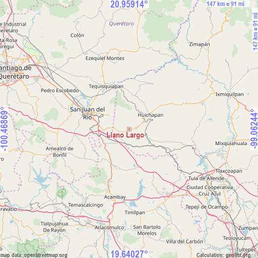
Llano Largo GPS coordinates[2]
20° 18' 3.996" North, 99° 45' 56.016" West
| Map corner | latitude | longitude |
|---|---|---|
| Upper-left | 20.95914°, | -100.46869° |
| Center: | 20.30111°, | -99.76556° |
| Lower-right: | 19.64027°, | -99.06244° |
| Map W x H: | 146.6×146.6 km | = 91.1×91.1mi |
| max Lat: | 32.7° ⇑36.5% North |
| Llano Largo: | 20.30111° |
| min Lat: | ⇓63.5% South 14.53588° |
| min Long | Llano Largo | max Long |
| -117.105° | -99.76556° | -86.73105° |
| W 39%⇐ | ⇒61% E |
Elevation
Elevation of Llano Largo is 2239 m = 7346 ft, and this is 985.3 m = 3233 ft above average elevation for this country.
| Max E: |
3497 m = 11473 ft | 16.2% |
| Llano Largo | 2239 m 7346 ft | |
| Avg. | 1253.7 m = 4113 ft | |
Min E: |
-1 m = -3 ft | 83.8% |
See also: Mexico elevation on elevation.city.
Geographical zone
Llano Largo is located in North Torrid zone (between Equator and Tropic of Cancer). Distance of this Northern Tropic circle is 348.6 km =216.6 mi to North.| Distance of | km | miles | from Llano Largo |
|---|---|---|---|
| North Pole | 7749.8 | 4815.5 | to North |
| Arctic Circle | 5143.9 | 3196.3 | to North |
| Tropic Cancer | 348.6 | 216.6 | to North |
| Equator | 2257.3 | 1402.6 | to South |


Nearby cities:
15 places around Llano Largo: (largest is in red/bold)
• Barrio Lázaro Cárdenas (San Rafael)
9.3 km =5.8 mi,  231°
231°
• Dongoteay
11 km =6.8 mi,  54°
54°
• El Carmen
5.9 km =3.7 mi,  273°
273°
• El Cazadero
11.1 km =6.9 mi, 269°
• El Saucillo
6.5 km =4 mi,  76°
76°
• El Álamo
10.8 km =6.7 mi,  196°
196°
• La Cruz
9.8 km =6.1 mi,  2°
2°
• La Purísima (Buenavista)
8.1 km =5 mi,  216°
216°
• Polotitlán de la Ilustración
9.9 km =6.2 mi,  211°
211°
• San Antonio el Viejo
11.7 km =7.3 mi, 209°
• San José Atlán
10.4 km =6.5 mi,  66°
66°
• San Lorenzo El Chico
4.7 km =2.9 mi,  184°
184°
• San Sebastián Tenochtitlán
8.3 km =5.2 mi,  106°
106°
• Tlaxcalilla
9.9 km =6.2 mi,  328°
328°
• Zothé
9.2 km =5.7 mi,  34°
34°
Sources, notices
• [Note1] Compared only with cities in Mexico existing in our database
• [Src1] Map data: © OpenStreetMap contributors (CC-BY-SA)
• [Src2] Other city data from geonames.org with taken over terms of usage.
• [Src3] Geographical zone / Annual Mean Temperature by Robert A. Rohde @ Wikipedia
