Tlaxcalilla geodata
Tlaxcalilla (Hidalgo) is a populated place; located in Mexico in America/Mexico_City (GMT-6) time zone. With population of 3,274 people, there are 2772 cities with bigger population in this country. Compared to other cities in Mexico, 65.1% of cities are located further ↓South; 61.6% of cities are located further →East and 82.9% of cities have lower elevation than Tlaxcalilla. Note1


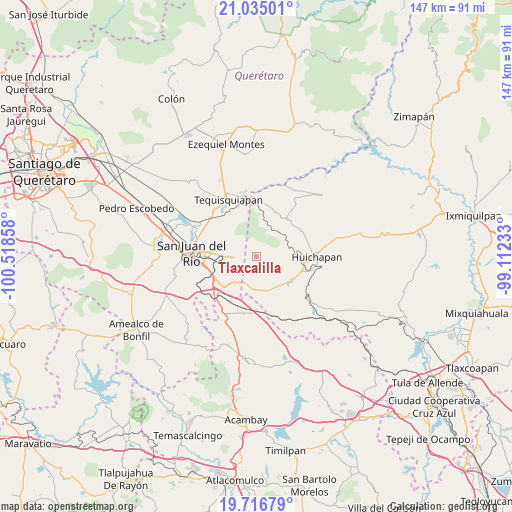
Tlaxcalilla GPS coordinates[2]
20° 22' 38.316" North, 99° 48' 55.62" West
| Map corner | latitude | longitude |
|---|---|---|
| Upper-left | 21.03501°, | -100.51858° |
| Center: | 20.37731°, | -99.81545° |
| Lower-right: | 19.71679°, | -99.11233° |
| Map W x H: | 146.6×146.6 km | = 91.1×91.1mi |
| max Lat: | 32.7° ⇑34.9% North |
| Tlaxcalilla: | 20.37731° |
| min Lat: | ⇓65.1% South 14.53588° |
| min Long | Tlaxcalilla | max Long |
| -117.105° | -99.81545° | -86.73105° |
| W 38.4%⇐ | ⇒61.6% E |
Elevation
Elevation of Tlaxcalilla is 2213 m = 7260 ft, and this is 959.3 m = 3147 ft above average elevation for this country.
| Max E: |
3497 m = 11473 ft | 17.1% |
| Tlaxcalilla | 2213 m 7260 ft | |
| Avg. | 1253.7 m = 4113 ft | |
Min E: |
-1 m = -3 ft | 82.9% |
See also: Mexico elevation on elevation.city.
Geographical zone
Tlaxcalilla is located in North Torrid zone (between Equator and Tropic of Cancer). Distance of this Northern Tropic circle is 340.2 km =211.4 mi to North.| Distance of | km | miles | from Tlaxcalilla |
|---|---|---|---|
| North Pole | 7741.3 | 4810.2 | to North |
| Arctic Circle | 5135.4 | 3191 | to North |
| Tropic Cancer | 340.2 | 211.4 | to North |
| Equator | 2265.7 | 1407.8 | to South |


Nearby cities:
15 places around Tlaxcalilla: (largest is in red/bold)
• Cerro Gordo
10.3 km =6.4 mi,  267°
267°
• El Carmen
8.1 km =5 mi,  184°
184°
• El Cazadero
10.4 km =6.5 mi,  214°
214°
• El Saucillo
13.5 km =8.4 mi,  121°
121°
• El Sitio
4.5 km =2.8 mi,  251°
251°
• La Cruz
5.9 km =3.7 mi,  76°
76°
• Llano Largo
9.9 km =6.2 mi,  148°
148°
• Maney
13.8 km =8.6 mi, 83°
• Palmillas
13.8 km =8.6 mi, 250°
• Paso de Mata
12.3 km =7.6 mi, 251°
• Puerta de Palmillas
12.8 km =8 mi,  235°
235°
• San Francisco
13.8 km =8.6 mi,  38°
38°
• Santa Rosa Xajay
10.9 km =6.8 mi,  307°
307°
• Villas Fundadores [Fraccionamiento]
9.8 km =6.1 mi, 270°
• Zothé
10.4 km =6.5 mi,  94°
94°
Sources, notices
• [Note1] Compared only with cities in Mexico existing in our database
• [Src1] Map data: © OpenStreetMap contributors (CC-BY-SA)
• [Src2] Other city data from geonames.org with taken over terms of usage.
• [Src3] Geographical zone / Annual Mean Temperature by Robert A. Rohde @ Wikipedia
