El Saucillo geodata
El Saucillo (Hidalgo) is a populated place; located in Mexico in America/Mexico_City (GMT-6) time zone. With population of 632 people, there are 13699 cities with bigger population in this country. Compared to other cities in Mexico, 63.8% of cities are located further ↓South; 60.3% of cities are located further →East and 81.7% of cities have lower elevation than El Saucillo. Note1


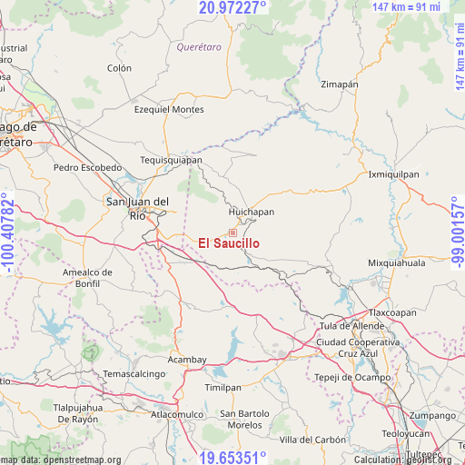
El Saucillo GPS coordinates[2]
20° 18' 51.444" North, 99° 42' 16.884" West
| Map corner | latitude | longitude |
|---|---|---|
| Upper-left | 20.97227°, | -100.40782° |
| Center: | 20.31429°, | -99.70469° |
| Lower-right: | 19.65351°, | -99.00157° |
| Map W x H: | 146.6×146.6 km | = 91.1×91.1mi |
| max Lat: | 32.7° ⇑36.2% North |
| El Saucillo: | 20.31429° |
| min Lat: | ⇓63.8% South 14.53588° |
| min Long | El Saucillo | max Long |
| -117.105° | -99.70469° | -86.73105° |
| W 39.7%⇐ | ⇒60.3% E |
Elevation
Elevation of El Saucillo is 2182 m = 7159 ft, and this is 928.3 m = 3046 ft above average elevation for this country.
| Max E: |
3497 m = 11473 ft | 18.3% |
| El Saucillo | 2182 m 7159 ft | |
| Avg. | 1253.7 m = 4113 ft | |
Min E: |
-1 m = -3 ft | 81.7% |
See also: Mexico elevation on elevation.city.
Geographical zone
El Saucillo is located in North Torrid zone (between Equator and Tropic of Cancer). Distance of this Northern Tropic circle is 347.2 km =215.7 mi to North.| Distance of | km | miles | from El Saucillo |
|---|---|---|---|
| North Pole | 7748.3 | 4814.6 | to North |
| Arctic Circle | 5142.4 | 3195.3 | to North |
| Tropic Cancer | 347.2 | 215.7 | to North |
| Equator | 2258.7 | 1403.5 | to South |


Nearby cities:
15 places around El Saucillo: (largest is in red/bold)
• Dongoteay
5.6 km =3.5 mi,  27°
27°
• El Cajón
11.5 km =7.1 mi,  45°
45°
• Huichapan
9 km =5.6 mi,  40°
40°
• La Cruz
10.2 km =6.3 mi,  325°
325°
• La Sabinita
9.1 km =5.7 mi, 53°
• Llano Largo
6.5 km =4 mi,  256°
256°
• Mamithi
11.7 km =7.3 mi,  24°
24°
• Maney
8.9 km =5.5 mi,  14°
14°
• Nopala de Villagran
9.3 km =5.8 mi,  138°
138°
• Pedregoso
6.8 km =4.2 mi,  73°
73°
• Sabina Grande
10.7 km =6.6 mi, 50°
• San José Atlán
4.2 km =2.6 mi, 50°
• San Lorenzo El Chico
9.1 km =5.7 mi,  227°
227°
• San Sebastián Tenochtitlán
4.2 km =2.6 mi,  156°
156°
• Zothé
6.3 km =3.9 mi,  349°
349°
Sources, notices
• [Note1] Compared only with cities in Mexico existing in our database
• [Src1] Map data: © OpenStreetMap contributors (CC-BY-SA)
• [Src2] Other city data from geonames.org with taken over terms of usage.
• [Src3] Geographical zone / Annual Mean Temperature by Robert A. Rohde @ Wikipedia
