San Sebastián Tenochtitlán geodata
San Sebastián Tenochtitlán (Hidalgo) is a populated place; located in Mexico in America/Mexico_City (GMT-6) time zone. With population of 2,155 people, there are 4077 cities with bigger population in this country. Compared to other cities in Mexico, 63.1% of cities are located further ↓South; 60.1% of cities are located further →East and 84.3% of cities have lower elevation than San Sebastián Tenochtitlán. Note1
Current local time in San Sebastián Tenochtitlán:
12:35 PM, MondayDifference from your time zone: hours


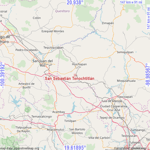
San Sebastián Tenochtitlán GPS coordinates[2]
20° 16' 47.568" North, 99° 41' 19.644" West
| Map corner | latitude | longitude |
|---|---|---|
| Upper-left | 20.938°, | -100.39192° |
| Center: | 20.27988°, | -99.68879° |
| Lower-right: | 19.61895°, | -98.98567° |
| Map W x H: | 146.7×146.7 km | = 91.2×91.2mi |
| max Lat: | 32.7° ⇑36.9% North |
| San Sebastián Tenochtitlán: | 20.27988° |
| min Lat: | ⇓63.1% South 14.53588° |
| min Long | San Sebastián | max Long |
| -117.105° | -99.68879° | -86.73105° |
| W 39.9%⇐ | ⇒60.1% E |
Elevation
Elevation of San Sebastián Tenochtitlán is 2247 m = 7372 ft, and this is 993.3 m = 3259 ft above average elevation for this country.
| Max E: |
3497 m = 11473 ft | 15.7% |
| San Sebastián Tenochtitlán | 2247 m 7372 ft | |
| Avg. | 1253.7 m = 4113 ft | |
Min E: |
-1 m = -3 ft | 84.3% |
See also: Mexico elevation on elevation.city.
Geographical zone
San Sebastián Tenochtitlán is located in North Torrid zone (between Equator and Tropic of Cancer). Distance of this Northern Tropic circle is 351 km =218.1 mi to North.| Distance of | km | miles | from San Sebastián Tenochtitlán |
|---|---|---|---|
| North Pole | 7752.2 | 4817 | to North |
| Arctic Circle | 5146.3 | 3197.8 | to North |
| Tropic Cancer | 351 | 218.1 | to North |
| Equator | 2254.9 | 1401.1 | to South |


Nearby cities:
15 places around San Sebastián Tenochtitlán: (largest is in red/bold)
• Dongoteay
8.8 km =5.5 mi,  5°
5°
• El Cajón
13.5 km =8.4 mi,  28°
28°
• El Jagüey
8.5 km =5.3 mi,  115°
115°
• El Saucillo
4.2 km =2.6 mi,  336°
336°
• Huichapan
11.5 km =7.1 mi,  21°
21°
• La Sabinita
10.8 km =6.7 mi, 31°
• Llano Largo
8.3 km =5.2 mi,  286°
286°
• Maney
12.5 km =7.8 mi,  2°
2°
• Maravillas
13.5 km =8.4 mi,  128°
128°
• Nopala de Villagran
5.5 km =3.4 mi, 124°
• Pedregoso
7.5 km =4.7 mi,  40°
40°
• Sabina Grande
12.5 km =7.8 mi, 32°
• San José Atlán
6.7 km =4.2 mi, 13°
• San Lorenzo El Chico
8.7 km =5.4 mi,  254°
254°
• Zothé
10.4 km =6.5 mi, 344°
Sources, notices
• [Note1] Compared only with cities in Mexico existing in our database
• [Src1] Map data: © OpenStreetMap contributors (CC-BY-SA)
• [Src2] Other city data from geonames.org with taken over terms of usage.
• [Src3] Geographical zone / Annual Mean Temperature by Robert A. Rohde @ Wikipedia
