San Buenaventura Atempan geodata
San Buenaventura Atempan (Tlaxcala) is a populated place; located in Mexico in America/Mexico_City (GMT-6) time zone. With population of 2,068 people, there are 4216 cities with bigger population in this country. Compared to other cities in Mexico, 58.2% of cities are located further ↑North; 60.9% of cities are located further ←West and 86.2% of cities have lower elevation than San Buenaventura Atempan. Note1
Current local time in San Buenaventura Atempan:
03:40 AM, WednesdayDifference from your time zone: hours


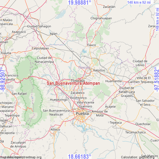
San Buenaventura Atempan GPS coordinates[2]
19° 19' 36.012" North, 98° 13' 18.984" West
| Map corner | latitude | longitude |
|---|---|---|
| Upper-left | 19.98881°, | -98.92507° |
| Center: | 19.32667°, | -98.22194° |
| Lower-right: | 18.66183°, | -97.51882° |
| Map W x H: | 147.5×147.5 km | = 91.7×91.7mi |
| max Lat: | 32.7° ⇑58.2% North |
| San Buenaventura Atempan: | 19.32667° |
| min Lat: | ⇓41.8% South 14.53588° |
| min Long | San Buenaventur | max Long |
| -117.105° | -98.22194° | -86.73105° |
| W 60.9%⇐ | ⇒39.1% E |
Elevation
Elevation of San Buenaventura Atempan is 2286 m = 7500 ft, and this is 1032.3 m = 3387 ft above average elevation for this country.
| Max E: |
3497 m = 11473 ft | 13.8% |
| San Buenaventura Atempan | 2286 m 7500 ft | |
| Avg. | 1253.7 m = 4113 ft | |
Min E: |
-1 m = -3 ft | 86.2% |
See also: Mexico elevation on elevation.city.
Geographical zone
San Buenaventura Atempan is located in North Torrid zone (between Equator and Tropic of Cancer). Distance of this Northern Tropic circle is 457 km =284 mi to North.| Distance of | km | miles | from San Buenaventura Atempan |
|---|---|---|---|
| North Pole | 7858.1 | 4882.8 | to North |
| Arctic Circle | 5252.2 | 3263.6 | to North |
| Tropic Cancer | 457 | 284 | to North |
| Equator | 2148.9 | 1335.3 | to South |


Nearby cities:
15 places around San Buenaventura Atempan: (largest is in red/bold)
• Acxotla del Río
1.7 km =1.1 mi,  260°
260°
• Belén Atzitzimititlán
4 km =2.5 mi,  56°
56°
• La Candelaria Teotlalpan
0.8 km =0.5 mi,  331°
331°
• La Trinidad Chimalpa
2.5 km =1.6 mi,  277°
277°
• Los Reyes Quiahuixtlan
3.4 km =2.1 mi,  294°
294°
• San Esteban Tizatlán
1.6 km =1 mi,  31°
31°
• San Hipólito Chimalpa
3.1 km =1.9 mi, 255°
• San Matías Tepetomatitlán
4.1 km =2.5 mi,  43°
43°
• San Miguel Tlamahuco
1.9 km =1.2 mi, 261°
• Santa María Ixtulco
1.4 km =0.9 mi,  96°
96°
• Santiago Tepeticpac
1 km =0.6 mi, 329°
• Tecolotla
4 km =2.5 mi,  70°
70°
• Tlatempan
2.1 km =1.3 mi, 74°
• Tlaxcala
2.5 km =1.6 mi,  110°
110°
• Totolac
3.8 km =2.4 mi,  268°
268°
Sources, notices
• [Note1] Compared only with cities in Mexico existing in our database
• [Src1] Map data: © OpenStreetMap contributors (CC-BY-SA)
• [Src2] Other city data from geonames.org with taken over terms of usage.
• [Src3] Geographical zone / Annual Mean Temperature by Robert A. Rohde @ Wikipedia
