Tlatempan geodata
Tlatempan (Tlaxcala) is a populated place; located in Mexico in America/Mexico_City (GMT-6) time zone. With population of 2,837 people, there are 3128 cities with bigger population in this country. Compared to other cities in Mexico, 58.1% of cities are located further ↑North; 61.2% of cities are located further ←West and 85.7% of cities have lower elevation than Tlatempan. Note1


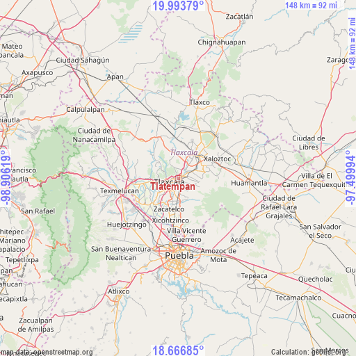
Tlatempan GPS coordinates[2]
19° 19' 54.012" North, 98° 12' 11.016" West
| Map corner | latitude | longitude |
|---|---|---|
| Upper-left | 19.99379°, | -98.90619° |
| Center: | 19.33167°, | -98.20306° |
| Lower-right: | 18.66685°, | -97.49994° |
| Map W x H: | 147.5×147.5 km | = 91.7×91.7mi |
| max Lat: | 32.7° ⇑58.1% North |
| Tlatempan: | 19.33167° |
| min Lat: | ⇓41.9% South 14.53588° |
| min Long | Tlatempan | max Long |
| -117.105° | -98.20306° | -86.73105° |
| W 61.2%⇐ | ⇒38.8% E |
Elevation
Elevation of Tlatempan is 2275 m = 7464 ft, and this is 1021.3 m = 3351 ft above average elevation for this country.
| Max E: |
3497 m = 11473 ft | 14.3% |
| Tlatempan | 2275 m 7464 ft | |
| Avg. | 1253.7 m = 4113 ft | |
Min E: |
-1 m = -3 ft | 85.7% |
See also: Mexico elevation on elevation.city.
Geographical zone
Tlatempan is located in North Torrid zone (between Equator and Tropic of Cancer). Distance of this Northern Tropic circle is 456.4 km =283.6 mi to North.| Distance of | km | miles | from Tlatempan |
|---|---|---|---|
| North Pole | 7857.6 | 4882.5 | to North |
| Arctic Circle | 5251.7 | 3263.3 | to North |
| Tropic Cancer | 456.4 | 283.6 | to North |
| Equator | 2149.5 | 1335.6 | to South |


Nearby cities:
15 places around Tlatempan: (largest is in red/bold)
• Acxotla del Río
3.7 km =2.3 mi,  257°
257°
• Amaxac de Guerrero
3.8 km =2.4 mi,  64°
64°
• Apetatitlán Antonio Carbajal
2.6 km =1.6 mi,  78°
78°
• Belén Atzitzimititlán
2.2 km =1.4 mi,  38°
38°
• Contla
3.9 km =2.4 mi,  93°
93°
• La Candelaria Teotlalpan
2.4 km =1.5 mi,  273°
273°
• San Buenaventura Atempan
2.1 km =1.3 mi,  254°
254°
• San Esteban Tizatlán
1.4 km =0.9 mi,  306°
306°
• San Matías Tepetomatitlán
2.6 km =1.6 mi,  19°
19°
• San Miguel Tlamahuco
3.9 km =2.4 mi, 257°
• Santa Ana Chiautempan
3.2 km =2 mi,  150°
150°
• Santa María Ixtulco
0.9 km =0.6 mi,  218°
218°
• Santiago Tepeticpac
2.5 km =1.6 mi,  277°
277°
• Tecolotla
1.9 km =1.2 mi,  66°
66°
• Tlaxcala
1.4 km =0.9 mi,  166°
166°
Sources, notices
• [Note1] Compared only with cities in Mexico existing in our database
• [Src1] Map data: © OpenStreetMap contributors (CC-BY-SA)
• [Src2] Other city data from geonames.org with taken over terms of usage.
• [Src3] Geographical zone / Annual Mean Temperature by Robert A. Rohde @ Wikipedia
