San José Chapayal geodata
San José Chapayal (Chiapas) is a populated place; located in Mexico in America/Mexico_City (GMT-6) time zone. With population of 2,059 people, there are 4236 cities with bigger population in this country. Compared to other cities in Mexico, 85.2% of cities are located further ↑North; 89.3% of cities are located further ←West and 55% of cities have higher elevation than San José Chapayal. Note1


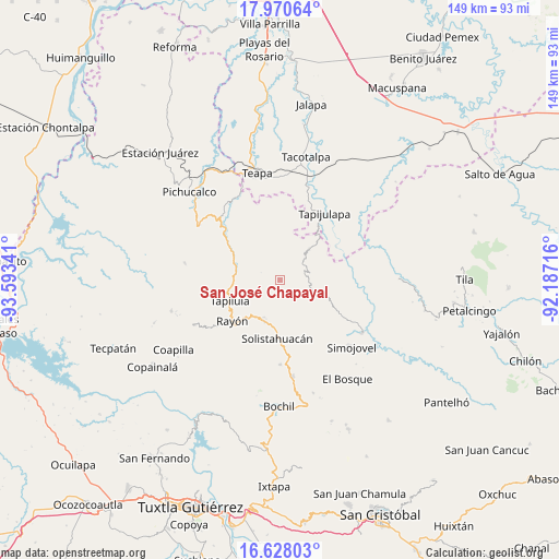
San José Chapayal GPS coordinates[2]
17° 18' 2.016" North, 92° 53' 25.008" West
| Map corner | latitude | longitude |
|---|---|---|
| Upper-left | 17.97064°, | -93.59341° |
| Center: | 17.30056°, | -92.89028° |
| Lower-right: | 16.62803°, | -92.18716° |
| Map W x H: | 149.3×149.3 km | = 92.8×92.8mi |
| max Lat: | 32.7° ⇑85.2% North |
| San José Chapayal: | 17.30056° |
| min Lat: | ⇓14.8% South 14.53588° |
| min Long | San José Chapa | max Long |
| -117.105° | -92.89028° | -86.73105° |
| W 89.3%⇐ | ⇒10.7% E |
Elevation
Elevation of San José Chapayal is 1199 m = 3934 ft, and this is 54.7 m = 179 ft below average elevation for this country.
| Max E: |
3497 m = 11473 ft | 55% |
| Avg. | 1253.7 m = 4113 ft | |
| San José Chapayal | 1199 m = 3934 ft | |
Min E: |
-1 m = -3 ft | 45% |
See also: Mexico elevation on elevation.city.
Geographical zone
San José Chapayal is located in North Torrid zone (between Equator and Tropic of Cancer). Distance of this Northern Tropic circle is 682.3 km =424 mi to North.| Distance of | km | miles | from San José Chapayal |
|---|---|---|---|
| North Pole | 8083.4 | 5022.8 | to North |
| Arctic Circle | 5477.5 | 3403.6 | to North |
| Tropic Cancer | 682.3 | 424 | to North |
| Equator | 1923.6 | 1195.3 | to South |


Nearby cities:
15 places around San José Chapayal: (largest is in red/bold)
• Aurora Ermita
7.4 km =4.6 mi,  166°
166°
• Año de Juárez
6.4 km =4 mi,  132°
132°
• Cerro las Campanas
9.6 km =6 mi,  293°
293°
• Chapallal Grande
5.8 km =3.6 mi,  265°
265°
• El Calvario
4.5 km =2.8 mi,  69°
69°
• El Porvenir Tres Picos
5 km =3.1 mi,  28°
28°
• Guadalupe Victoria
7.8 km =4.8 mi,  14°
14°
• Ignacio Zaragoza
5.2 km =3.2 mi,  256°
256°
• La Esperanza
9.7 km =6 mi,  81°
81°
• La Florida
8.9 km =5.5 mi,  226°
226°
• Reforma y Planada
9.9 km =6.2 mi,  15°
15°
• San Antonio Tres Picos
4 km =2.5 mi,  50°
50°
• Santa Anita
9.3 km =5.8 mi, 267°
• Villaflores
9.7 km =6 mi,  309°
309°
• Zacatonal de Juárez
10.2 km =6.3 mi,  108°
108°
Sources, notices
• [Note1] Compared only with cities in Mexico existing in our database
• [Src1] Map data: © OpenStreetMap contributors (CC-BY-SA)
• [Src2] Other city data from geonames.org with taken over terms of usage.
• [Src3] Geographical zone / Annual Mean Temperature by Robert A. Rohde @ Wikipedia
