Reforma y Planada geodata
Reforma y Planada (Chiapas) is a populated place; located in Mexico in America/Mexico_City (GMT-6) time zone. With population of 1,156 people, there are 7503 cities with bigger population in this country. Compared to other cities in Mexico, 84.3% of cities are located further ↑North; 89.4% of cities are located further ←West and 69.7% of cities have higher elevation than Reforma y Planada. Note1


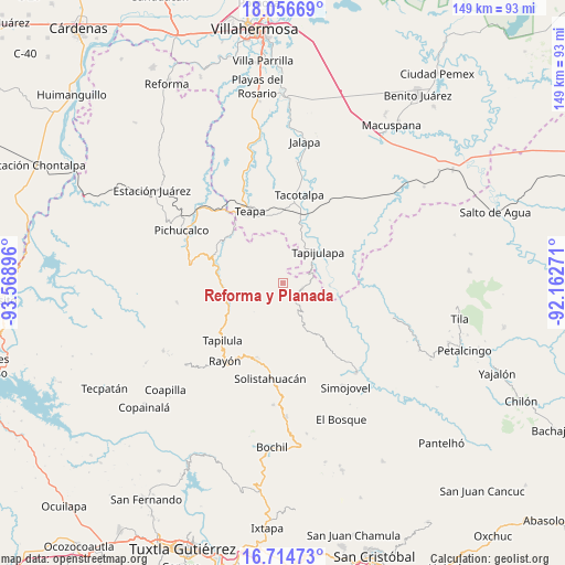
Reforma y Planada GPS coordinates[2]
17° 23' 12.984" North, 92° 51' 56.988" West
| Map corner | latitude | longitude |
|---|---|---|
| Upper-left | 18.05669°, | -93.56896° |
| Center: | 17.38694°, | -92.86583° |
| Lower-right: | 16.71473°, | -92.16271° |
| Map W x H: | 149.2×149.2 km | = 92.7×92.7mi |
| max Lat: | 32.7° ⇑84.3% North |
| Reforma y Planada: | 17.38694° |
| min Lat: | ⇓15.7% South 14.53588° |
| min Long | Reforma y Plana | max Long |
| -117.105° | -92.86583° | -86.73105° |
| W 89.4%⇐ | ⇒10.6% E |
Elevation
Elevation of Reforma y Planada is 431 m = 1414 ft, and this is 822.7 m = 2699 ft below average elevation for this country.
| Max E: |
3497 m = 11473 ft | 69.7% |
| Avg. | 1253.7 m = 4113 ft | |
| Reforma y Planada | 431 m = 1414 ft | |
Min E: |
-1 m = -3 ft | 30.3% |
See also: Mexico elevation on elevation.city.
Geographical zone
Reforma y Planada is located in North Torrid zone (between Equator and Tropic of Cancer). Distance of this Northern Tropic circle is 672.7 km =418 mi to North.| Distance of | km | miles | from Reforma y Planada |
|---|---|---|---|
| North Pole | 8073.8 | 5016.8 | to North |
| Arctic Circle | 5467.9 | 3397.6 | to North |
| Tropic Cancer | 672.7 | 418 | to North |
| Equator | 1933.2 | 1201.2 | to South |


Nearby cities:
15 places around Reforma y Planada: (largest is in red/bold)
• Amatán
5.2 km =3.2 mi,  105°
105°
• Cerro las Campanas
12.8 km =8 mi,  242°
242°
• El Calvario
8.2 km =5.1 mi,  168°
168°
• El Porvenir Tres Picos
5.2 km =3.2 mi,  182°
182°
• Francisco I. Madero
8.2 km =5.1 mi,  317°
317°
• Guadalupe Victoria
2.1 km =1.3 mi,  197°
197°
• La Esperanza
10.8 km =6.7 mi,  139°
139°
• La Gloria
11.2 km =7 mi,  303°
303°
• Lázaro Cárdenas
8.2 km =5.1 mi,  265°
265°
• Oxolotán
12.4 km =7.7 mi,  93°
93°
• San Antonio Tres Picos
7 km =4.3 mi, 175°
• San José Chapayal
9.9 km =6.2 mi, 195°
• Tapijulapa
12.4 km =7.7 mi,  47°
47°
• Villaflores
10.6 km =6.6 mi,  251°
251°
• Zunu y Patastal
11.2 km =7 mi,  30°
30°
Sources, notices
• [Note1] Compared only with cities in Mexico existing in our database
• [Src1] Map data: © OpenStreetMap contributors (CC-BY-SA)
• [Src2] Other city data from geonames.org with taken over terms of usage.
• [Src3] Geographical zone / Annual Mean Temperature by Robert A. Rohde @ Wikipedia
