La Esperanza geodata
La Esperanza (Chiapas) is a populated place; located in Mexico in America/Mexico_City (GMT-6) time zone. With population of 552 people, there are 15449 cities with bigger population in this country. Compared to other cities in Mexico, 85.1% of cities are located further ↑North; 89.8% of cities are located further ←West and 64.6% of cities have higher elevation than La Esperanza. Note1


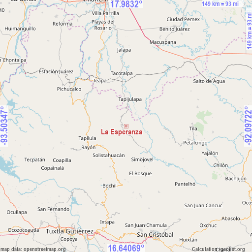
La Esperanza GPS coordinates[2]
17° 18' 47.412" North, 92° 48' 1.224" West
| Map corner | latitude | longitude |
|---|---|---|
| Upper-left | 17.9832°, | -93.50347° |
| Center: | 17.31317°, | -92.80034° |
| Lower-right: | 16.64069°, | -92.09722° |
| Map W x H: | 149.3×149.3 km | = 92.8×92.8mi |
| max Lat: | 32.7° ⇑85.1% North |
| La Esperanza: | 17.31317° |
| min Lat: | ⇓14.9% South 14.53588° |
| min Long | La Esperanza | max Long |
| -117.105° | -92.80034° | -86.73105° |
| W 89.8%⇐ | ⇒10.2% E |
Elevation
Elevation of La Esperanza is 710 m = 2329 ft, and this is 543.7 m = 1784 ft below average elevation for this country.
| Max E: |
3497 m = 11473 ft | 64.6% |
| Avg. | 1253.7 m = 4113 ft | |
| La Esperanza | 710 m = 2329 ft | |
Min E: |
-1 m = -3 ft | 35.4% |
See also: Mexico elevation on elevation.city.
Geographical zone
La Esperanza is located in North Torrid zone (between Equator and Tropic of Cancer). Distance of this Northern Tropic circle is 680.9 km =423.1 mi to North.| Distance of | km | miles | from La Esperanza |
|---|---|---|---|
| North Pole | 8082 | 5021.9 | to North |
| Arctic Circle | 5476.1 | 3402.7 | to North |
| Tropic Cancer | 680.9 | 423.1 | to North |
| Equator | 1925 | 1196.1 | to South |


Nearby cities:
15 places around La Esperanza: (largest is in red/bold)
• Amatán
7.1 km =4.4 mi,  343°
343°
• Año de Juárez
7.5 km =4.7 mi,  219°
219°
• Cuitláhuac
8.8 km =5.5 mi,  56°
56°
• El Calvario
5.4 km =3.4 mi,  271°
271°
• El Porvenir Tres Picos
7.8 km =4.8 mi,  292°
292°
• Guadalupe Victoria
9.8 km =6.1 mi,  309°
309°
• Huanal
8.3 km =5.2 mi,  95°
95°
• La Competencia
9.7 km =6 mi,  151°
151°
• Oxolotán
9.1 km =5.7 mi,  36°
36°
• San Antonio Tres Picos
6.6 km =4.1 mi,  280°
280°
• San José Chapayal
9.7 km =6 mi,  261°
261°
• Sombra Carrizal
6 km =3.7 mi,  107°
107°
• Villa Luz
9.4 km =5.8 mi, 112°
• Zacajtic
8 km =5 mi, 149°
• Zacatonal de Juárez
4.7 km =2.9 mi,  178°
178°
Sources, notices
• [Note1] Compared only with cities in Mexico existing in our database
• [Src1] Map data: © OpenStreetMap contributors (CC-BY-SA)
• [Src2] Other city data from geonames.org with taken over terms of usage.
• [Src3] Geographical zone / Annual Mean Temperature by Robert A. Rohde @ Wikipedia
