Año de Juárez geodata
Año de Juárez (Chiapas) is a populated place; located in Mexico in America/Mexico_City (GMT-6) time zone. With population of 665 people, there are 13061 cities with bigger population in this country. Compared to other cities in Mexico, 85.8% of cities are located further ↑North; 89.6% of cities are located further ←West and 65.2% of cities have higher elevation than Año de Juárez. Note1


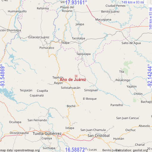
Año de Juárez GPS coordinates[2]
17° 15' 41.004" North, 92° 50' 44.016" West
| Map corner | latitude | longitude |
|---|---|---|
| Upper-left | 17.93161°, | -93.54869° |
| Center: | 17.26139°, | -92.84556° |
| Lower-right: | 16.58872°, | -92.14244° |
| Map W x H: | 149.3×149.3 km | = 92.8×92.8mi |
| max Lat: | 32.7° ⇑85.8% North |
| Año de Juárez: | 17.26139° |
| min Lat: | ⇓14.2% South 14.53588° |
| min Long | Año de Juárez | max Long |
| -117.105° | -92.84556° | -86.73105° |
| W 89.6%⇐ | ⇒10.4% E |
Elevation
Elevation of Año de Juárez is 675 m = 2215 ft, and this is 578.7 m = 1899 ft below average elevation for this country.
| Max E: |
3497 m = 11473 ft | 65.2% |
| Avg. | 1253.7 m = 4113 ft | |
| Año de Juárez | 675 m = 2215 ft | |
Min E: |
-1 m = -3 ft | 34.8% |
See also: Mexico elevation on elevation.city.
Geographical zone
Año de Juárez is located in North Torrid zone (between Equator and Tropic of Cancer). Distance of this Northern Tropic circle is 686.6 km =426.6 mi to North.| Distance of | km | miles | from Año de Juárez |
|---|---|---|---|
| North Pole | 8087.8 | 5025.5 | to North |
| Arctic Circle | 5481.9 | 3406.3 | to North |
| Tropic Cancer | 686.6 | 426.6 | to North |
| Equator | 1919.3 | 1192.6 | to South |


Nearby cities:
15 places around Año de Juárez: (largest is in red/bold)
• Arroyo Grande
8.3 km =5.2 mi,  199°
199°
• Aurora Ermita
4.1 km =2.5 mi,  226°
226°
• El Calvario
6 km =3.7 mi,  354°
354°
• El Porvenir Tres Picos
9.1 km =5.7 mi,  344°
344°
• Ignacio Zaragoza
10.3 km =6.4 mi,  287°
287°
• La Competencia
9.8 km =6.1 mi,  106°
106°
• La Esperanza
7.5 km =4.7 mi,  39°
39°
• Lázaro Cárdenas
7.9 km =4.9 mi,  173°
173°
• San Antonio Tres Picos
7.1 km =4.4 mi, 346°
• San José Chapayal
6.4 km =4 mi,  312°
312°
• San Rafael
9.5 km =5.9 mi,  135°
135°
• Sombra Carrizal
11.2 km =7 mi,  69°
69°
• Sonora
9.9 km =6.2 mi, 174°
• Zacajtic
9 km =5.6 mi,  97°
97°
• Zacatonal de Juárez
5 km =3.1 mi,  77°
77°
Sources, notices
• [Note1] Compared only with cities in Mexico existing in our database
• [Src1] Map data: © OpenStreetMap contributors (CC-BY-SA)
• [Src2] Other city data from geonames.org with taken over terms of usage.
• [Src3] Geographical zone / Annual Mean Temperature by Robert A. Rohde @ Wikipedia
