Cuatzoquitengo geodata
Cuatzoquitengo (Guerrero) is a populated place; located in Mexico in America/Mexico_City (GMT-6) time zone. With population of 1,920 people, there are 4531 cities with bigger population in this country. Compared to other cities in Mexico, 85.4% of cities are located further ↑North; 55.9% of cities are located further ←West and 75.4% of cities have lower elevation than Cuatzoquitengo. Note1


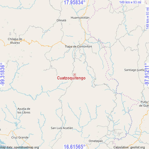
Cuatzoquitengo GPS coordinates[2]
17° 17' 17.592" North, 98° 36' 54.828" West
| Map corner | latitude | longitude |
|---|---|---|
| Upper-left | 17.95834°, | -99.31836° |
| Center: | 17.28822°, | -98.61523° |
| Lower-right: | 16.61565°, | -97.91211° |
| Map W x H: | 149.3×149.3 km | = 92.8×92.8mi |
| max Lat: | 32.7° ⇑85.4% North |
| Cuatzoquitengo: | 17.28822° |
| min Lat: | ⇓14.6% South 14.53588° |
| min Long | Cuatzoquitengo | max Long |
| -117.105° | -98.61523° | -86.73105° |
| W 55.9%⇐ | ⇒44.1% E |
Elevation
Elevation of Cuatzoquitengo is 2038 m = 6686 ft, and this is 784.3 m = 2573 ft above average elevation for this country.
| Max E: |
3497 m = 11473 ft | 24.6% |
| Cuatzoquitengo | 2038 m 6686 ft | |
| Avg. | 1253.7 m = 4113 ft | |
Min E: |
-1 m = -3 ft | 75.4% |
See also: Mexico elevation on elevation.city.
Geographical zone
Cuatzoquitengo is located in North Torrid zone (between Equator and Tropic of Cancer). Distance of this Northern Tropic circle is 683.6 km =424.8 mi to North.| Distance of | km | miles | from Cuatzoquitengo |
|---|---|---|---|
| North Pole | 8084.8 | 5023.7 | to North |
| Arctic Circle | 5478.9 | 3404.4 | to North |
| Tropic Cancer | 683.6 | 424.8 | to North |
| Equator | 1922.3 | 1194.5 | to South |


Nearby cities:
15 places around Cuatzoquitengo: (largest is in red/bold)
• Atlamajalcingo del Monte
2.8 km =1.7 mi,  25°
25°
• El Tejocote
6.5 km =4 mi,  314°
314°
• Francisco I. Madero
11.5 km =7.1 mi,  79°
79°
• Huehuetepec
3.4 km =2.1 mi,  131°
131°
• Juanacatlán
11.8 km =7.3 mi,  68°
68°
• Malinaltepec
7.6 km =4.7 mi,  230°
230°
• Mixtecapa
5.9 km =3.7 mi,  192°
192°
• Moyotepec (Moyotepec de Juárez)
8.9 km =5.5 mi,  302°
302°
• Ocoapa
12.5 km =7.8 mi,  328°
328°
• Ojo de Agua de Cuauhtémoc
10.6 km =6.6 mi,  204°
204°
• San Juan Puerto Montaña
10.1 km =6.3 mi,  95°
95°
• San Vicente Amole
12.2 km =7.6 mi, 304°
• Santa Cruz
8.8 km =5.5 mi, 68°
• Tepecocatlán
3.9 km =2.4 mi,  356°
356°
• Zilacayotitlán
7 km =4.3 mi, 83°
Sources, notices
• [Note1] Compared only with cities in Mexico existing in our database
• [Src1] Map data: © OpenStreetMap contributors (CC-BY-SA)
• [Src2] Other city data from geonames.org with taken over terms of usage.
• [Src3] Geographical zone / Annual Mean Temperature by Robert A. Rohde @ Wikipedia
