Malinaltepec geodata
Malinaltepec (Guerrero) is a seat of a second-order administrative division; located in Mexico in America/Mexico_City (GMT-6) time zone. With population of 1,187 people, there are 7318 cities with bigger population in this country. Compared to other cities in Mexico, 86% of cities are located further ↑North; 55.4% of cities are located further ←West and 51.9% of cities have lower elevation than Malinaltepec. Note1


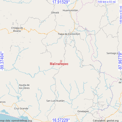
Malinaltepec GPS coordinates[2]
17° 14' 42.036" North, 98° 40' 15.276" West
| Map corner | latitude | longitude |
|---|---|---|
| Upper-left | 17.91529°, | -99.37404° |
| Center: | 17.24501°, | -98.67091° |
| Lower-right: | 16.57229°, | -97.96779° |
| Map W x H: | 149.3×149.3 km | = 92.8×92.8mi |
| max Lat: | 32.7° ⇑86% North |
| Malinaltepec: | 17.24501° |
| min Lat: | ⇓14% South 14.53588° |
| min Long | Malinaltepec | max Long |
| -117.105° | -98.67091° | -86.73105° |
| W 55.4%⇐ | ⇒44.6% E |
Elevation
Elevation of Malinaltepec is 1522 m = 4993 ft, and this is 268.3 m = 880 ft above average elevation for this country.
| Max E: |
3497 m = 11473 ft | 48.1% |
| Malinaltepec | 1522 m 4993 ft | |
| Avg. | 1253.7 m = 4113 ft | |
Min E: |
-1 m = -3 ft | 51.9% |
See also: Mexico elevation on elevation.city.
Geographical zone
Malinaltepec is located in North Torrid zone (between Equator and Tropic of Cancer). Distance of this Northern Tropic circle is 688.5 km =427.8 mi to North.| Distance of | km | miles | from Malinaltepec |
|---|---|---|---|
| North Pole | 8089.6 | 5026.6 | to North |
| Arctic Circle | 5483.7 | 3407.4 | to North |
| Tropic Cancer | 688.5 | 427.8 | to North |
| Equator | 1917.5 | 1191.5 | to South |


Nearby cities:
15 places around Malinaltepec: (largest is in red/bold)
• Atlamajalcingo del Monte
10.3 km =6.4 mi,  43°
43°
• Cuatzoquitengo
7.6 km =4.7 mi,  50°
50°
• El Capulín
14.5 km =9 mi,  291°
291°
• El Tejocote
9.4 km =5.8 mi,  7°
7°
• El Tejocote
14.7 km =9.1 mi,  282°
282°
• Huehuetepec
8.9 km =5.5 mi,  73°
73°
• Mixtecapa
4.7 km =2.9 mi,  101°
101°
• Moyotepec (Moyotepec de Juárez)
9.8 km =6.1 mi,  350°
350°
• Ojo de Agua de Cuauhtémoc
5.1 km =3.2 mi,  162°
162°
• Paraje Montero (Paraje Montero de Zaragoza)
9.7 km =6 mi,  201°
201°
• San Vicente Amole
12.4 km =7.7 mi,  340°
340°
• Tapayoltepec
7.4 km =4.6 mi,  207°
207°
• Tepecocatlán
10.4 km =6.5 mi,  33°
33°
• Tlacoapa
8.5 km =5.3 mi, 284°
• Zilacayotitlán
14 km =8.7 mi, 66°
Sources, notices
• [Note1] Compared only with cities in Mexico existing in our database
• [Src1] Map data: © OpenStreetMap contributors (CC-BY-SA)
• [Src2] Other city data from geonames.org with taken over terms of usage.
• [Src3] Geographical zone / Annual Mean Temperature by Robert A. Rohde @ Wikipedia
