San Bartolomé Hueyapan geodata
San Bartolomé Hueyapan (Puebla) is a populated place; located in Mexico in America/Mexico_City (GMT-6) time zone. With population of 1,869 people, there are 4645 cities with bigger population in this country. Compared to other cities in Mexico, 64.3% of cities are located further ↑North; 64.4% of cities are located further ←West and 86.1% of cities have lower elevation than San Bartolomé Hueyapan. Note1
Current local time in San Bartolomé Hueyapan:
08:30 AM, WednesdayDifference from your time zone: hours


San Bartolomé Hueyapan GPS coordinates[2]
19° 1' 31.008" North, 97° 55' 50.016" West
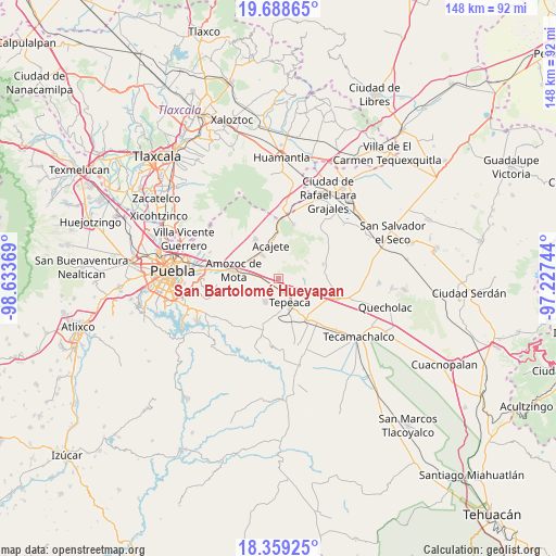
| Map corner | latitude | longitude |
|---|---|---|
| Upper-left | 19.68865°, | -98.63369° |
| Center: | 19.02528°, | -97.93056° |
| Lower-right: | 18.35925°, | -97.22744° |
| Map W x H: | 147.8×147.8 km | = 91.8×91.8mi |
| max Lat: | 32.7° ⇑64.3% North |
| San Bartolomé Hueyapan: | 19.02528° |
| min Lat: | ⇓35.7% South 14.53588° |
| min Long | San Bartolomé | max Long |
| -117.105° | -97.93056° | -86.73105° |
| W 64.4%⇐ | ⇒35.6% E |
Elevation
Elevation of San Bartolomé Hueyapan is 2285 m = 7497 ft, and this is 1031.3 m = 3384 ft above average elevation for this country.
| Max E: |
3497 m = 11473 ft | 13.9% |
| San Bartolomé Hueyapan | 2285 m 7497 ft | |
| Avg. | 1253.7 m = 4113 ft | |
Min E: |
-1 m = -3 ft | 86.1% |
See also: Mexico elevation on elevation.city.
Geographical zone
San Bartolomé Hueyapan is located in North Torrid zone (between Equator and Tropic of Cancer). Distance of this Northern Tropic circle is 490.5 km =304.8 mi to North.| Distance of | km | miles | from San Bartolomé Hueyapan |
|---|---|---|---|
| North Pole | 7891.6 | 4903.6 | to North |
| Arctic Circle | 5285.8 | 3284.4 | to North |
| Tropic Cancer | 490.5 | 304.8 | to North |
| Equator | 2115.4 | 1314.4 | to South |


Nearby cities:
15 places around San Bartolomé Hueyapan: (largest is in red/bold)
• Apango de Zaragoza
4.9 km =3 mi,  347°
347°
• Benito Juárez
7.9 km =4.9 mi,  103°
103°
• La Magdalena Tetela Morelos
2.9 km =1.8 mi,  336°
336°
• San Agustín Tlaxco
7.3 km =4.5 mi,  298°
298°
• San Antonio Tlacamilco
4.2 km =2.6 mi,  0°
0°
• San Felipe Tenextepec
5.9 km =3.7 mi,  83°
83°
• San Jerónimo Ocotitla
3.5 km =2.2 mi,  280°
280°
• San José Carpinteros
3.9 km =2.4 mi,  149°
149°
• Santa María Nenetzintla
5 km =3.1 mi,  310°
310°
• Santiago Acatlán
3.6 km =2.2 mi,  185°
185°
• Tepatlaxco de Hidalgo
7.6 km =4.7 mi,  323°
323°
• Tepeaca
7.3 km =4.5 mi, 153°
• Tlacamilco
5.8 km =3.6 mi,  14°
14°
• Zahuatlán de Morelos (San José)
8.1 km =5 mi,  125°
125°
• Álvaro Obregón
3 km =1.9 mi, 84°
Sources, notices
• [Note1] Compared only with cities in Mexico existing in our database
• [Src1] Map data: © OpenStreetMap contributors (CC-BY-SA)
• [Src2] Other city data from geonames.org with taken over terms of usage.
• [Src3] Geographical zone / Annual Mean Temperature by Robert A. Rohde @ Wikipedia
