San Felipe Tenextepec geodata
San Felipe Tenextepec (Puebla) is a populated place; located in Mexico in America/Mexico_City (GMT-6) time zone. With population of 804 people, there are 10860 cities with bigger population in this country. Compared to other cities in Mexico, 64.1% of cities are located further ↑North; 65.1% of cities are located further ←West and 86.9% of cities have lower elevation than San Felipe Tenextepec. Note1
Current local time in San Felipe Tenextepec:
06:46 AM, WednesdayDifference from your time zone: hours


San Felipe Tenextepec GPS coordinates[2]
19° 1' 52.86" North, 97° 52' 28.74" West
| Map corner | latitude | longitude |
|---|---|---|
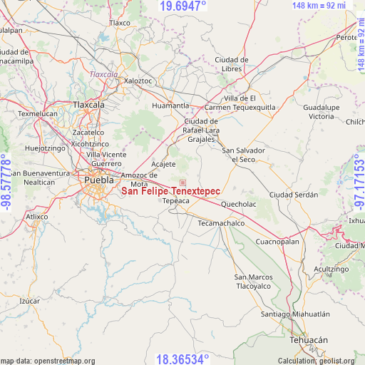
| Upper-left | 19.6947°, | -98.57778° |
| Center: | 19.03135°, | -97.87465° |
| Lower-right: | 18.36534°, | -97.17153° |
| Map W x H: | 147.8×147.8 km | = 91.8×91.8mi |
| max Lat: | 32.7° ⇑64.1% North |
| San Felipe Tenextepec: | 19.03135° |
| min Lat: | ⇓35.9% South 14.53588° |
| min Long | San Felipe Tene | max Long |
| -117.105° | -97.87465° | -86.73105° |
| W 65.1%⇐ | ⇒34.9% E |
Elevation
Elevation of San Felipe Tenextepec is 2308 m = 7572 ft, and this is 1054.3 m = 3459 ft above average elevation for this country.
| Max E: |
3497 m = 11473 ft | 13.1% |
| San Felipe Tenextepec | 2308 m 7572 ft | |
| Avg. | 1253.7 m = 4113 ft | |
Min E: |
-1 m = -3 ft | 86.9% |
See also: Mexico elevation on elevation.city.
Geographical zone
San Felipe Tenextepec is located in North Torrid zone (between Equator and Tropic of Cancer). Distance of this Northern Tropic circle is 489.8 km =304.3 mi to North.| Distance of | km | miles | from San Felipe Tenextepec |
|---|---|---|---|
| North Pole | 7891 | 4903.2 | to North |
| Arctic Circle | 5285.1 | 3284 | to North |
| Tropic Cancer | 489.8 | 304.3 | to North |
| Equator | 2116.1 | 1314.9 | to South |


Nearby cities:
15 places around San Felipe Tenextepec: (largest is in red/bold)
• Benito Juárez
3.1 km =1.9 mi,  143°
143°
• Carmen Serdán
6.6 km =4.1 mi,  85°
85°
• Los Reyes de Ocampo
4.4 km =2.7 mi,  59°
59°
• Nicolás Bravo
5.7 km =3.5 mi,  107°
107°
• San Bartolomé Hueyapan
5.9 km =3.7 mi,  263°
263°
• San Cristóbal los Nava
6 km =3.7 mi,  131°
131°
• San Francisco Buenavista
4.1 km =2.5 mi,  97°
97°
• San José Carpinteros
5.6 km =3.5 mi,  223°
223°
• San Lorenzo Joya de Rodríguez
3.4 km =2.1 mi,  41°
41°
• San Mateo Parra
4.6 km =2.9 mi,  162°
162°
• San Miguel
4.6 km =2.9 mi,  26°
26°
• San Pedro la Joya
5.4 km =3.4 mi,  45°
45°
• Tlacamilco
6.6 km =4.1 mi,  318°
318°
• Zahuatlán de Morelos (San José)
5.4 km =3.4 mi,  171°
171°
• Álvaro Obregón
2.9 km =1.8 mi, 262°
Sources, notices
• [Note1] Compared only with cities in Mexico existing in our database
• [Src1] Map data: © OpenStreetMap contributors (CC-BY-SA)
• [Src2] Other city data from geonames.org with taken over terms of usage.
• [Src3] Geographical zone / Annual Mean Temperature by Robert A. Rohde @ Wikipedia
