Los Cues geodata
Los Cues (Querétaro) is a populated place; located in Mexico in America/Mexico_City (GMT-6) time zone. With population of 1,622 people, there are 5334 cities with bigger population in this country. Compared to other cities in Mexico, 67.8% of cities are located further ↓South; 67% of cities are located further →East and 73.4% of cities have lower elevation than Los Cues. Note1


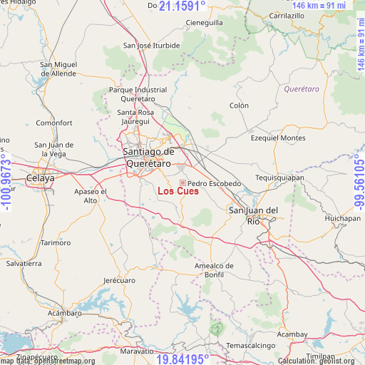
Los Cues GPS coordinates[2]
20° 30' 6.984" North, 100° 15' 51.012" West
| Map corner | latitude | longitude |
|---|---|---|
| Upper-left | 21.1591°, | -100.9673° |
| Center: | 20.50194°, | -100.26417° |
| Lower-right: | 19.84195°, | -99.56105° |
| Map W x H: | 146.5×146.5 km | = 91×91mi |
| max Lat: | 32.7° ⇑32.2% North |
| Los Cues: | 20.50194° |
| min Lat: | ⇓67.8% South 14.53588° |
| min Long | Los Cues | max Long |
| -117.105° | -100.26417° | -86.73105° |
| W 33%⇐ | ⇒67% E |
Elevation
Elevation of Los Cues is 1999 m = 6558 ft, and this is 745.3 m = 2445 ft above average elevation for this country.
| Max E: |
3497 m = 11473 ft | 26.6% |
| Los Cues | 1999 m 6558 ft | |
| Avg. | 1253.7 m = 4113 ft | |
Min E: |
-1 m = -3 ft | 73.4% |
See also: Mexico elevation on elevation.city.
Geographical zone
Los Cues is located in North Torrid zone (between Equator and Tropic of Cancer). Distance of this Northern Tropic circle is 326.3 km =202.8 mi to North.| Distance of | km | miles | from Los Cues |
|---|---|---|---|
| North Pole | 7727.5 | 4801.6 | to North |
| Arctic Circle | 5121.6 | 3182.4 | to North |
| Tropic Cancer | 326.3 | 202.8 | to North |
| Equator | 2279.6 | 1416.5 | to South |


Nearby cities:
15 places around Los Cues: (largest is in red/bold)
• Ajuchitlancito
5.8 km =3.6 mi,  119°
119°
• El Carmen
8.4 km =5.2 mi,  342°
342°
• El Colorado
6.9 km =4.3 mi,  16°
16°
• El Milagro
9.4 km =5.8 mi,  250°
250°
• El Paraíso
8.5 km =5.3 mi,  35°
35°
• El Rosario
5.3 km =3.3 mi,  298°
298°
• General Lázaro Cárdenas (El Colorado)
7.2 km =4.5 mi, 17°
• Guadalupe Primero
4.7 km =2.9 mi,  242°
242°
• La Noria
8.6 km =5.3 mi,  277°
277°
• La Piedad
8.6 km =5.3 mi,  5°
5°
• Lagunillas
5.8 km =3.6 mi,  213°
213°
• Palo Alto
6.2 km =3.9 mi,  46°
46°
• San Antonio la Galera
3.6 km =2.2 mi, 47°
• San Cristobal (El Colorado)
6.2 km =3.9 mi, 11°
• Santa Teresa
4 km =2.5 mi,  258°
258°
Sources, notices
• [Note1] Compared only with cities in Mexico existing in our database
• [Src1] Map data: © OpenStreetMap contributors (CC-BY-SA)
• [Src2] Other city data from geonames.org with taken over terms of usage.
• [Src3] Geographical zone / Annual Mean Temperature by Robert A. Rohde @ Wikipedia
