Guadalupe Victoria geodata
Guadalupe Victoria (Puebla) is a populated place; located in Mexico in America/Mexico_City (GMT-6) time zone. With population of 1,517 people, there are 5684 cities with bigger population in this country. Compared to other cities in Mexico, 52.9% of cities are located further ↑North; 67.8% of cities are located further ←West and 90.9% of cities have lower elevation than Guadalupe Victoria. Note1


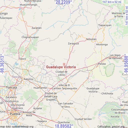
Guadalupe Victoria GPS coordinates[2]
19° 33' 34.992" North, 97° 39' 36" West
| Map corner | latitude | longitude |
|---|---|---|
| Upper-left | 20.2209°, | -98.36313° |
| Center: | 19.55972°, | -97.66° |
| Lower-right: | 18.89582°, | -96.95688° |
| Map W x H: | 147.3×147.3 km | = 91.5×91.5mi |
| max Lat: | 32.7° ⇑52.9% North |
| Guadalupe Victoria: | 19.55972° |
| min Lat: | ⇓47.1% South 14.53588° |
| min Long | Guadalupe Victo | max Long |
| -117.105° | -97.66° | -86.73105° |
| W 67.8%⇐ | ⇒32.2% E |
Elevation
Elevation of Guadalupe Victoria is 2436 m = 7992 ft, and this is 1182.3 m = 3879 ft above average elevation for this country.
| Max E: |
3497 m = 11473 ft | 9.1% |
| Guadalupe Victoria | 2436 m 7992 ft | |
| Avg. | 1253.7 m = 4113 ft | |
Min E: |
-1 m = -3 ft | 90.9% |
See also: Mexico elevation on elevation.city.
Geographical zone
Guadalupe Victoria is located in North Torrid zone (between Equator and Tropic of Cancer). Distance of this Northern Tropic circle is 431.1 km =267.9 mi to North.| Distance of | km | miles | from Guadalupe Victoria |
|---|---|---|---|
| North Pole | 7832.2 | 4866.7 | to North |
| Arctic Circle | 5226.3 | 3247.5 | to North |
| Tropic Cancer | 431.1 | 267.9 | to North |
| Equator | 2174.8 | 1351.4 | to South |


Nearby cities:
15 places around Guadalupe Victoria: (largest is in red/bold)
• Allende
7 km =4.3 mi,  109°
109°
• Cuauhtzolco
8.5 km =5.3 mi,  194°
194°
• Cuyoaco
6.3 km =3.9 mi,  41°
41°
• El Mirador (San Francisco)
2.6 km =1.6 mi,  184°
184°
• La Cañada
10.3 km =6.4 mi,  228°
228°
• La Unión Ejido Mexcaltepec
7.5 km =4.7 mi,  315°
315°
• Ocotepec
1.1 km =0.7 mi,  117°
117°
• Oyametepec
10.7 km =6.6 mi,  269°
269°
• Progreso
8.1 km =5 mi, 192°
• San Andrés Payuca
5.8 km =3.6 mi,  130°
130°
• San José la Libertad
9.4 km =5.8 mi,  207°
207°
• Tateno
8.3 km =5.2 mi,  309°
309°
• Tehuatzingo
4.7 km =2.9 mi,  203°
203°
• Temextla
5.5 km =3.4 mi,  352°
352°
• Tepexoxuca
10.4 km =6.5 mi,  291°
291°
Sources, notices
• [Note1] Compared only with cities in Mexico existing in our database
• [Src1] Map data: © OpenStreetMap contributors (CC-BY-SA)
• [Src2] Other city data from geonames.org with taken over terms of usage.
• [Src3] Geographical zone / Annual Mean Temperature by Robert A. Rohde @ Wikipedia
