Allende geodata
Allende (Puebla) is a populated place; located in Mexico in America/Mexico_City (GMT-6) time zone. With population of 1,064 people, there are 8203 cities with bigger population in this country. Compared to other cities in Mexico, 53.3% of cities are located further ↑North; 68.4% of cities are located further ←West and 89% of cities have lower elevation than Allende. Note1


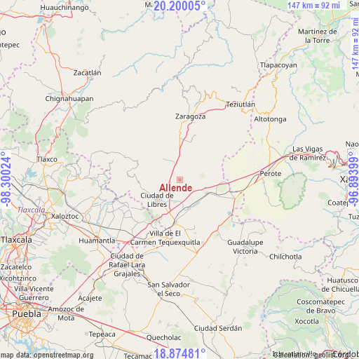
Allende GPS coordinates[2]
19° 32' 19.644" North, 97° 35' 49.596" West
| Map corner | latitude | longitude |
|---|---|---|
| Upper-left | 20.20005°, | -98.30024° |
| Center: | 19.53879°, | -97.59711° |
| Lower-right: | 18.87481°, | -96.89399° |
| Map W x H: | 147.4×147.4 km | = 91.6×91.6mi |
| max Lat: | 32.7° ⇑53.3% North |
| Allende: | 19.53879° |
| min Lat: | ⇓46.7% South 14.53588° |
| min Long | Allende | max Long |
| -117.105° | -97.59711° | -86.73105° |
| W 68.4%⇐ | ⇒31.6% E |
Elevation
Elevation of Allende is 2372 m = 7782 ft, and this is 1118.3 m = 3669 ft above average elevation for this country.
| Max E: |
3497 m = 11473 ft | 11% |
| Allende | 2372 m 7782 ft | |
| Avg. | 1253.7 m = 4113 ft | |
Min E: |
-1 m = -3 ft | 89% |
See also: Mexico elevation on elevation.city.
Geographical zone
Allende is located in North Torrid zone (between Equator and Tropic of Cancer). Distance of this Northern Tropic circle is 433.4 km =269.3 mi to North.| Distance of | km | miles | from Allende |
|---|---|---|---|
| North Pole | 7834.6 | 4868.2 | to North |
| Arctic Circle | 5228.7 | 3249 | to North |
| Tropic Cancer | 433.4 | 269.3 | to North |
| Equator | 2172.5 | 1349.9 | to South |


Nearby cities:
15 places around Allende: (largest is in red/bold)
• Cuauhtzolco
10.5 km =6.5 mi,  235°
235°
• Cuyoaco
7.4 km =4.6 mi,  340°
340°
• El Mirador (San Francisco)
6.8 km =4.2 mi,  268°
268°
• Guadalupe Victoria
7 km =4.3 mi,  289°
289°
• Libres
12.5 km =7.8 mi,  229°
229°
• Nuevo México
9.6 km =6 mi,  192°
192°
• Ocotepec
5.9 km =3.7 mi, 287°
• Progreso
10.1 km =6.3 mi, 236°
• San Andrés Payuca
2.6 km =1.6 mi, 236°
• Tehuatzingo
8.7 km =5.4 mi,  256°
256°
• Temextla
10.7 km =6.6 mi,  316°
316°
• Tepeyehualco de Hidalgo
12.3 km =7.6 mi,  116°
116°
• Tetipanapa
10.3 km =6.4 mi,  141°
141°
• Texcal
8.8 km =5.5 mi,  49°
49°
• Xaltipanapa
10.9 km =6.8 mi,  73°
73°
Sources, notices
• [Note1] Compared only with cities in Mexico existing in our database
• [Src1] Map data: © OpenStreetMap contributors (CC-BY-SA)
• [Src2] Other city data from geonames.org with taken over terms of usage.
• [Src3] Geographical zone / Annual Mean Temperature by Robert A. Rohde @ Wikipedia
