San Andrés Payuca geodata
San Andrés Payuca (Puebla) is a populated place; located in Mexico in America/Mexico_City (GMT-6) time zone. With population of 3,372 people, there are 2692 cities with bigger population in this country. Compared to other cities in Mexico, 53.6% of cities are located further ↑North; 68.2% of cities are located further ←West and 89.6% of cities have lower elevation than San Andrés Payuca. Note1


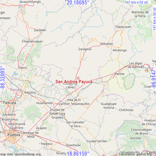
San Andrés Payuca GPS coordinates[2]
19° 31' 32.268" North, 97° 37' 4.152" West
| Map corner | latitude | longitude |
|---|---|---|
| Upper-left | 20.18695°, | -98.32095° |
| Center: | 19.52563°, | -97.61782° |
| Lower-right: | 18.86159°, | -96.9147° |
| Map W x H: | 147.4×147.4 km | = 91.6×91.6mi |
| max Lat: | 32.7° ⇑53.6% North |
| San Andrés Payuca: | 19.52563° |
| min Lat: | ⇓46.4% South 14.53588° |
| min Long | San Andrés Pay | max Long |
| -117.105° | -97.61782° | -86.73105° |
| W 68.2%⇐ | ⇒31.8% E |
Elevation
Elevation of San Andrés Payuca is 2392 m = 7848 ft, and this is 1138.3 m = 3735 ft above average elevation for this country.
| Max E: |
3497 m = 11473 ft | 10.4% |
| San Andrés Payuca | 2392 m 7848 ft | |
| Avg. | 1253.7 m = 4113 ft | |
Min E: |
-1 m = -3 ft | 89.6% |
See also: Mexico elevation on elevation.city.
Geographical zone
San Andrés Payuca is located in North Torrid zone (between Equator and Tropic of Cancer). Distance of this Northern Tropic circle is 434.9 km =270.2 mi to North.| Distance of | km | miles | from San Andrés Payuca |
|---|---|---|---|
| North Pole | 7836 | 4869.1 | to North |
| Arctic Circle | 5230.1 | 3249.8 | to North |
| Tropic Cancer | 434.9 | 270.2 | to North |
| Equator | 2171 | 1349 | to South |


Nearby cities:
15 places around San Andrés Payuca: (largest is in red/bold)
• Allende
2.6 km =1.6 mi,  56°
56°
• Cuauhtzolco
7.9 km =4.9 mi,  235°
235°
• Cuyoaco
8.5 km =5.3 mi,  358°
358°
• El Mirador (San Francisco)
4.8 km =3 mi,  284°
284°
• Guadalupe Victoria
5.8 km =3.6 mi,  310°
310°
• Libres
9.9 km =6.2 mi,  227°
227°
• Nuevo México
7.9 km =4.9 mi,  179°
179°
• Ocotepec
4.8 km =3 mi, 313°
• Progreso
7.5 km =4.7 mi, 236°
• San José la Libertad
9.9 km =6.2 mi, 242°
• Tehuatzingo
6.3 km =3.9 mi,  264°
264°
• Temextla
10.6 km =6.6 mi,  330°
330°
• Tetipanapa
10.8 km =6.7 mi,  127°
127°
• Texcal
11.4 km =7.1 mi,  51°
51°
• Álvaro Obregón (San Francisco)
11.1 km =6.9 mi,  215°
215°
Sources, notices
• [Note1] Compared only with cities in Mexico existing in our database
• [Src1] Map data: © OpenStreetMap contributors (CC-BY-SA)
• [Src2] Other city data from geonames.org with taken over terms of usage.
• [Src3] Geographical zone / Annual Mean Temperature by Robert A. Rohde @ Wikipedia
