Apas geodata
Apas (Chiapas) is a populated place; located in Mexico in America/Mexico_City (GMT-6) time zone. With population of 1,485 people, there are 5810 cities with bigger population in this country. Compared to other cities in Mexico, 92.7% of cities are located further ↑North; 89.9% of cities are located further ←West and 79.3% of cities have lower elevation than Apas. Note1


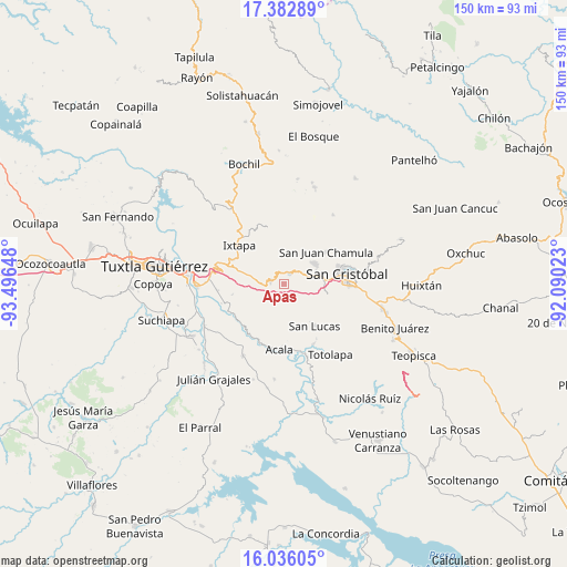
Apas GPS coordinates[2]
16° 42' 38.376" North, 92° 47' 36.06" West
| Map corner | latitude | longitude |
|---|---|---|
| Upper-left | 17.38289°, | -93.49648° |
| Center: | 16.71066°, | -92.79335° |
| Lower-right: | 16.03605°, | -92.09023° |
| Map W x H: | 149.8×149.8 km | = 93.1×93.1mi |
| max Lat: | 32.7° ⇑92.7% North |
| Apas: | 16.71066° |
| min Lat: | ⇓7.3% South 14.53588° |
| min Long | Apas | max Long |
| -117.105° | -92.79335° | -86.73105° |
| W 89.9%⇐ | ⇒10.1% E |
Elevation
Elevation of Apas is 2124 m = 6969 ft, and this is 870.3 m = 2855 ft above average elevation for this country.
| Max E: |
3497 m = 11473 ft | 20.7% |
| Apas | 2124 m 6969 ft | |
| Avg. | 1253.7 m = 4113 ft | |
Min E: |
-1 m = -3 ft | 79.3% |
See also: Mexico elevation on elevation.city.
Geographical zone
Apas is located in North Torrid zone (between Equator and Tropic of Cancer). Distance of this Northern Tropic circle is 747.9 km =464.7 mi to North.| Distance of | km | miles | from Apas |
|---|---|---|---|
| North Pole | 8149 | 5063.6 | to North |
| Arctic Circle | 5543.1 | 3444.3 | to North |
| Tropic Cancer | 747.9 | 464.7 | to North |
| Equator | 1858.1 | 1154.6 | to South |


Nearby cities:
15 places around Apas: (largest is in red/bold)
• Bochojbo Alto
8.6 km =5.3 mi,  71°
71°
• Chiquinivalvo
6.2 km =3.9 mi,  267°
267°
• El Pig
3.8 km =2.4 mi,  52°
52°
• Jech Chentic
6.3 km =3.9 mi, 69°
• Jechtoch
8.1 km =5 mi,  78°
78°
• Jobchenón (La Granadilla)
4.6 km =2.9 mi, 265°
• Multajo
8.5 km =5.3 mi,  278°
278°
• Nachig
7.6 km =4.7 mi, 73°
• Navenchauc
3.1 km =1.9 mi,  29°
29°
• Pasté
5.6 km =3.5 mi,  97°
97°
• Patosil
7.2 km =4.5 mi, 50°
• Shulvo
6.5 km =4 mi, 78°
• Yalentay (San Joaquín)
4.9 km =3 mi,  55°
55°
• Zequentic
3.6 km =2.2 mi, 281°
• Zinacantán
9.3 km =5.8 mi, 53°
Sources, notices
• [Note1] Compared only with cities in Mexico existing in our database
• [Src1] Map data: © OpenStreetMap contributors (CC-BY-SA)
• [Src2] Other city data from geonames.org with taken over terms of usage.
• [Src3] Geographical zone / Annual Mean Temperature by Robert A. Rohde @ Wikipedia
