Jech Chentic geodata
Jech Chentic (Chiapas) is a populated place; located in Mexico in America/Mexico_City (GMT-6) time zone. With population of 892 people, there are 9779 cities with bigger population in this country. Compared to other cities in Mexico, 92.5% of cities are located further ↑North; 90.2% of cities are located further ←West and 86.3% of cities have lower elevation than Jech Chentic. Note1


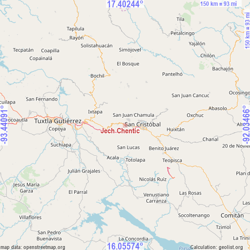
Jech Chentic GPS coordinates[2]
16° 43' 49.008" North, 92° 44' 16.008" West
| Map corner | latitude | longitude |
|---|---|---|
| Upper-left | 17.40244°, | -93.44091° |
| Center: | 16.73028°, | -92.73778° |
| Lower-right: | 16.05574°, | -92.03466° |
| Map W x H: | 149.7×149.7 km | = 93×93mi |
| max Lat: | 32.7° ⇑92.5% North |
| Jech Chentic: | 16.73028° |
| min Lat: | ⇓7.5% South 14.53588° |
| min Long | Jech Chentic | max Long |
| -117.105° | -92.73778° | -86.73105° |
| W 90.2%⇐ | ⇒9.8% E |
Elevation
Elevation of Jech Chentic is 2289 m = 7510 ft, and this is 1035.3 m = 3397 ft above average elevation for this country.
| Max E: |
3497 m = 11473 ft | 13.7% |
| Jech Chentic | 2289 m 7510 ft | |
| Avg. | 1253.7 m = 4113 ft | |
Min E: |
-1 m = -3 ft | 86.3% |
See also: Mexico elevation on elevation.city.
Geographical zone
Jech Chentic is located in North Torrid zone (between Equator and Tropic of Cancer). Distance of this Northern Tropic circle is 745.7 km =463.4 mi to North.| Distance of | km | miles | from Jech Chentic |
|---|---|---|---|
| North Pole | 8146.8 | 5062.2 | to North |
| Arctic Circle | 5540.9 | 3443 | to North |
| Tropic Cancer | 745.7 | 463.4 | to North |
| Equator | 1860.2 | 1155.9 | to South |


Nearby cities:
15 places around Jech Chentic: (largest is in red/bold)
• Arvenza Uno
5.8 km =3.6 mi,  18°
18°
• Bahosil
5.6 km =3.5 mi,  11°
11°
• Bochojbo Alto
2.3 km =1.4 mi,  74°
74°
• Catishtic
5.6 km =3.5 mi,  0°
0°
• El Pig
2.9 km =1.8 mi,  273°
273°
• Jechtoch
2.1 km =1.3 mi,  106°
106°
• La Ventana
6 km =3.7 mi,  48°
48°
• Nachig
1.3 km =0.8 mi,  88°
88°
• Navenchauc
4.4 km =2.7 mi,  276°
276°
• Pasté
2.9 km =1.8 mi,  186°
186°
• Patosil
2.5 km =1.6 mi,  351°
351°
• Shulvo
1 km =0.6 mi,  153°
153°
• Yalentay (San Joaquín)
2 km =1.2 mi,  287°
287°
• Zacualpa Ecatepec
5.1 km =3.2 mi,  120°
120°
• Zinacantán
3.7 km =2.3 mi,  25°
25°
Sources, notices
• [Note1] Compared only with cities in Mexico existing in our database
• [Src1] Map data: © OpenStreetMap contributors (CC-BY-SA)
• [Src2] Other city data from geonames.org with taken over terms of usage.
• [Src3] Geographical zone / Annual Mean Temperature by Robert A. Rohde @ Wikipedia
