Bochojbo Alto geodata
Bochojbo Alto (Chiapas) is a populated place; located in Mexico in America/Mexico_City (GMT-6) time zone. With population of 1,088 people, there are 8000 cities with bigger population in this country. Compared to other cities in Mexico, 92.4% of cities are located further ↑North; 90.4% of cities are located further ←West and 91% of cities have lower elevation than Bochojbo Alto. Note1


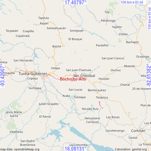
Bochojbo Alto GPS coordinates[2]
16° 44' 8.988" North, 92° 43' 0.984" West
| Map corner | latitude | longitude |
|---|---|---|
| Upper-left | 17.40797°, | -93.42007° |
| Center: | 16.73583°, | -92.71694° |
| Lower-right: | 16.06131°, | -92.01382° |
| Map W x H: | 149.7×149.7 km | = 93×93mi |
| max Lat: | 32.7° ⇑92.4% North |
| Bochojbo Alto: | 16.73583° |
| min Lat: | ⇓7.6% South 14.53588° |
| min Long | Bochojbo Alto | max Long |
| -117.105° | -92.71694° | -86.73105° |
| W 90.4%⇐ | ⇒9.6% E |
Elevation
Elevation of Bochojbo Alto is 2442 m = 8012 ft, and this is 1188.3 m = 3899 ft above average elevation for this country.
| Max E: |
3497 m = 11473 ft | 9% |
| Bochojbo Alto | 2442 m 8012 ft | |
| Avg. | 1253.7 m = 4113 ft | |
Min E: |
-1 m = -3 ft | 91% |
See also: Mexico elevation on elevation.city.
Geographical zone
Bochojbo Alto is located in North Torrid zone (between Equator and Tropic of Cancer). Distance of this Northern Tropic circle is 745.1 km =463 mi to North.| Distance of | km | miles | from Bochojbo Alto |
|---|---|---|---|
| North Pole | 8146.2 | 5061.8 | to North |
| Arctic Circle | 5540.3 | 3442.6 | to North |
| Tropic Cancer | 745.1 | 463 | to North |
| Equator | 1860.8 | 1156.2 | to South |


Nearby cities:
15 places around Bochojbo Alto: (largest is in red/bold)
• Arvenza Uno
4.9 km =3 mi,  355°
355°
• Bechijtic
5 km =3.1 mi,  28°
28°
• Cuchulumtic
4.8 km =3 mi,  16°
16°
• Ichintón
4.7 km =2.9 mi,  52°
52°
• Jech Chentic
2.3 km =1.4 mi,  254°
254°
• Jechtoch
1.2 km =0.7 mi,  188°
188°
• La Selva Natividad
3.8 km =2.4 mi, 50°
• La Ventana
4.1 km =2.5 mi, 34°
• Nachig
1.1 km =0.7 mi,  236°
236°
• Pasté
4.4 km =2.7 mi,  216°
216°
• Patosil
3.2 km =2 mi,  304°
304°
• Shulvo
2.3 km =1.4 mi,  229°
229°
• Yalentay (San Joaquín)
4.1 km =2.5 mi,  269°
269°
• Zacualpa Ecatepec
3.9 km =2.4 mi,  146°
146°
• Zinacantán
2.8 km =1.7 mi,  347°
347°
Sources, notices
• [Note1] Compared only with cities in Mexico existing in our database
• [Src1] Map data: © OpenStreetMap contributors (CC-BY-SA)
• [Src2] Other city data from geonames.org with taken over terms of usage.
• [Src3] Geographical zone / Annual Mean Temperature by Robert A. Rohde @ Wikipedia
