Zinacantán geodata
Zinacantán (Chiapas) is a seat of a second-order administrative division; located in Mexico in America/Mexico_City (GMT-6) time zone. With population of 3,876 people, there are 2362 cities with bigger population in this country. Compared to other cities in Mexico, 92.2% of cities are located further ↑North; 90.3% of cities are located further ←West and 80.8% of cities have lower elevation than Zinacantán. Note1


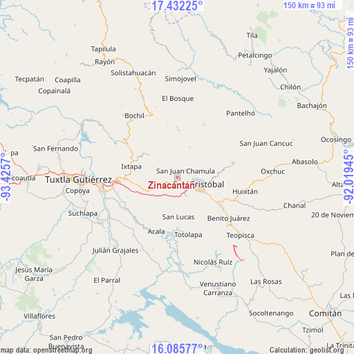
Zinacantán GPS coordinates[2]
16° 45' 36.72" North, 92° 43' 21.252" West
| Map corner | latitude | longitude |
|---|---|---|
| Upper-left | 17.43225°, | -93.4257° |
| Center: | 16.7602°, | -92.72257° |
| Lower-right: | 16.08577°, | -92.01945° |
| Map W x H: | 149.7×149.7 km | = 93×93mi |
| max Lat: | 32.7° ⇑92.2% North |
| Zinacantán: | 16.7602° |
| min Lat: | ⇓7.8% South 14.53588° |
| min Long | Zinacantán | max Long |
| -117.105° | -92.72257° | -86.73105° |
| W 90.3%⇐ | ⇒9.7% E |
Elevation
Elevation of Zinacantán is 2160 m = 7087 ft, and this is 906.3 m = 2973 ft above average elevation for this country.
| Max E: |
3497 m = 11473 ft | 19.2% |
| Zinacantán | 2160 m 7087 ft | |
| Avg. | 1253.7 m = 4113 ft | |
Min E: |
-1 m = -3 ft | 80.8% |
See also: Mexico elevation on elevation.city.
Geographical zone
Zinacantán is located in North Torrid zone (between Equator and Tropic of Cancer). Distance of this Northern Tropic circle is 742.4 km =461.3 mi to North.| Distance of | km | miles | from Zinacantán |
|---|---|---|---|
| North Pole | 8143.5 | 5060.1 | to North |
| Arctic Circle | 5537.6 | 3440.9 | to North |
| Tropic Cancer | 742.4 | 461.3 | to North |
| Equator | 1863.6 | 1158 | to South |


Nearby cities:
15 places around Zinacantán: (largest is in red/bold)
• Arvenza Uno
2.2 km =1.4 mi,  6°
6°
• Bahosil
2.2 km =1.4 mi,  346°
346°
• Bautista Grande
4.2 km =2.6 mi, 351°
• Bechijtic
3.4 km =2.1 mi,  60°
60°
• Bochojbo Alto
2.8 km =1.7 mi,  167°
167°
• Catishtic
2.8 km =1.7 mi,  324°
324°
• Cuchulumtic
2.7 km =1.7 mi,  45°
45°
• Ichintón
4.3 km =2.7 mi,  87°
87°
• Jech Chentic
3.7 km =2.3 mi,  205°
205°
• Jechtoch
3.9 km =2.4 mi, 173°
• La Selva Natividad
3.6 km =2.2 mi, 94°
• La Ventana
3 km =1.9 mi,  77°
77°
• Nachig
3.3 km =2.1 mi,  185°
185°
• Patosil
2.2 km =1.4 mi,  245°
245°
• Ukumtic
3.5 km =2.2 mi, 345°
Sources, notices
• [Note1] Compared only with cities in Mexico existing in our database
• [Src1] Map data: © OpenStreetMap contributors (CC-BY-SA)
• [Src2] Other city data from geonames.org with taken over terms of usage.
• [Src3] Geographical zone / Annual Mean Temperature by Robert A. Rohde @ Wikipedia
