Guachipilín geodata
Guachipilín (Chiapas) is a populated place; located in Mexico in America/Mexico_City (GMT-6) time zone. With population of 765 people, there are 11448 cities with bigger population in this country. Compared to other cities in Mexico, 99.5% of cities are located further ↑North; 92.5% of cities are located further ←West and 90.8% of cities have higher elevation than Guachipilín. Note1


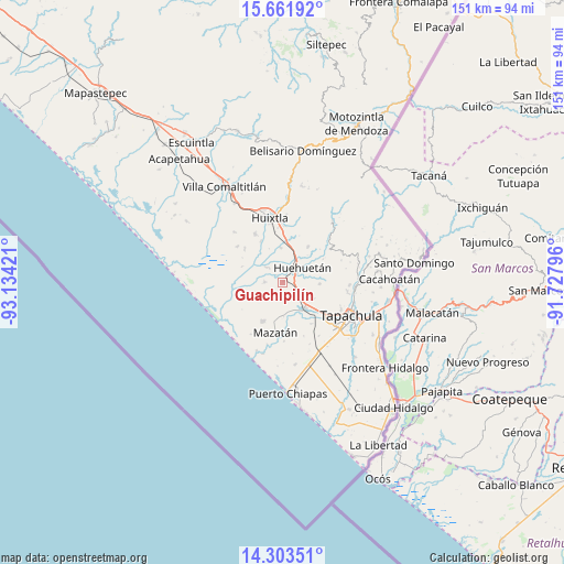
Guachipilín GPS coordinates[2]
14° 59' 1.644" North, 92° 25' 51.888" West
| Map corner | latitude | longitude |
|---|---|---|
| Upper-left | 15.66192°, | -93.13421° |
| Center: | 14.98379°, | -92.43108° |
| Lower-right: | 14.30351°, | -91.72796° |
| Map W x H: | 151×151 km | = 93.8×93.8mi |
| max Lat: | 32.7° ⇑99.5% North |
| Guachipilín: | 14.98379° |
| min Lat: | ⇓0.5% South 14.53588° |
| min Long | Guachipilín | max Long |
| -117.105° | -92.43108° | -86.73105° |
| W 92.5%⇐ | ⇒7.5% E |
Elevation
Elevation of Guachipilín is 22 m = 72 ft, and this is 1231.7 m = 4041 ft below average elevation for this country.
| Max E: |
3497 m = 11473 ft | 90.8% |
| Avg. | 1253.7 m = 4113 ft | |
| Guachipilín | 22 m = 72 ft | |
Min E: |
-1 m = -3 ft | 9.2% |
See also: Mexico elevation on elevation.city.
Geographical zone
Guachipilín is located in North Torrid zone (between Equator and Tropic of Cancer). Distance of this Northern Tropic circle is 939.9 km =584 mi to North.| Distance of | km | miles | from Guachipilín |
|---|---|---|---|
| North Pole | 8341 | 5182.9 | to North |
| Arctic Circle | 5735.1 | 3563.6 | to North |
| Tropic Cancer | 939.9 | 584 | to North |
| Equator | 1666 | 1035.2 | to South |


Nearby cities:
15 places around Guachipilín: (largest is in red/bold)
• Cantón la Lima
4.7 km =2.9 mi,  355°
355°
• Chamulapa
8.3 km =5.2 mi,  20°
20°
• Cuntalapa
6 km =3.7 mi,  37°
37°
• Cuyamiapa
6.1 km =3.8 mi,  12°
12°
• Estación Huehuetán
4 km =2.5 mi, 41°
• Guadalupe
9.9 km =6.2 mi,  92°
92°
• Huehuetán
6.6 km =4.1 mi,  52°
52°
• Marte R. Gómez
6.5 km =4 mi,  192°
192°
• Nueva Victoria
6.1 km =3.8 mi,  311°
311°
• Nuevo Pumpuapa (Cereso)
9.6 km =6 mi,  132°
132°
• Plan de Ayala
4.9 km =3 mi,  270°
270°
• Plan de Iguala
8.3 km =5.2 mi,  251°
251°
• San José el Amate
1.4 km =0.9 mi,  331°
331°
• Unión Miramar
9.5 km =5.9 mi,  117°
117°
• Álvaro Obregón
8.9 km =5.5 mi,  140°
140°
Sources, notices
• [Note1] Compared only with cities in Mexico existing in our database
• [Src1] Map data: © OpenStreetMap contributors (CC-BY-SA)
• [Src2] Other city data from geonames.org with taken over terms of usage.
• [Src3] Geographical zone / Annual Mean Temperature by Robert A. Rohde @ Wikipedia
