Las Nieves geodata
Las Nieves (Puebla) is a populated place; located in Mexico in America/Mexico_City (GMT-6) time zone. With population of 1,290 people, there are 6724 cities with bigger population in this country. Compared to other cities in Mexico, 76.4% of cities are located further ↑North; 63.1% of cities are located further ←West and 55.5% of cities have higher elevation than Las Nieves. Note1


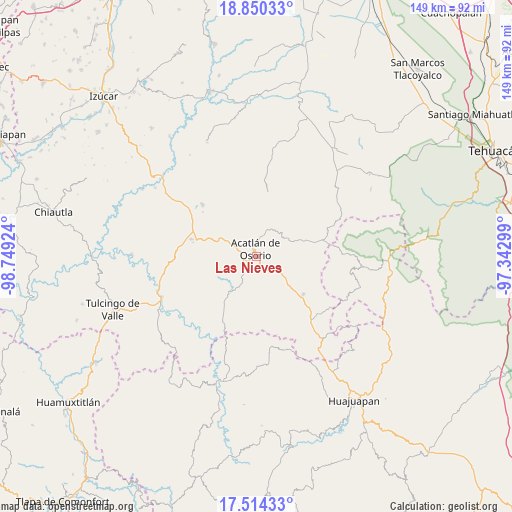
Las Nieves GPS coordinates[2]
18° 11' 0.996" North, 98° 2' 45.996" West
| Map corner | latitude | longitude |
|---|---|---|
| Upper-left | 18.85033°, | -98.74924° |
| Center: | 18.18361°, | -98.04611° |
| Lower-right: | 17.51433°, | -97.34299° |
| Map W x H: | 148.5×148.6 km | = 92.3×92.3mi |
| max Lat: | 32.7° ⇑76.4% North |
| Las Nieves: | 18.18361° |
| min Lat: | ⇓23.6% South 14.53588° |
| min Long | Las Nieves | max Long |
| -117.105° | -98.04611° | -86.73105° |
| W 63.1%⇐ | ⇒36.9% E |
Elevation
Elevation of Las Nieves is 1180 m = 3871 ft, and this is 73.7 m = 242 ft below average elevation for this country.
| Max E: |
3497 m = 11473 ft | 55.5% |
| Avg. | 1253.7 m = 4113 ft | |
| Las Nieves | 1180 m = 3871 ft | |
Min E: |
-1 m = -3 ft | 44.5% |
See also: Mexico elevation on elevation.city.
Geographical zone
Las Nieves is located in North Torrid zone (between Equator and Tropic of Cancer). Distance of this Northern Tropic circle is 584.1 km =362.9 mi to North.| Distance of | km | miles | from Las Nieves |
|---|---|---|---|
| North Pole | 7985.2 | 4961.8 | to North |
| Arctic Circle | 5379.3 | 3342.5 | to North |
| Tropic Cancer | 584.1 | 362.9 | to North |
| Equator | 2021.8 | 1256.3 | to South |


Nearby cities:
15 places around Las Nieves: (largest is in red/bold)
• Acatlán de Osorio
2.1 km =1.3 mi,  352°
352°
• Amatitlán de Azueta
3.3 km =2.1 mi,  255°
255°
• Gabino Barreda
10.1 km =6.3 mi,  99°
99°
• Garzones (Santa Gertrudis)
10.7 km =6.6 mi,  9°
9°
• Hermenegildo Galeana
10.1 km =6.3 mi,  323°
323°
• La Huerta
8.9 km =5.5 mi,  23°
23°
• Mixquitlixco
6.4 km =4 mi,  216°
216°
• San Bernardo
7 km =4.3 mi,  297°
297°
• San Francisco Rancho Nuevo
8.6 km =5.3 mi, 349°
• San Isidro Labrador
9 km =5.6 mi,  196°
196°
• San Pablo Anicano
7.8 km =4.8 mi,  211°
211°
• San Pedro Yeloixtlahuacan
8.1 km =5 mi, 203°
• Tetelcingo
6.5 km =4 mi, 18°
• Tianguistengo
8.5 km =5.3 mi, 21°
• Xayacatlán de Bravo
9.6 km =6 mi,  51°
51°
Sources, notices
• [Note1] Compared only with cities in Mexico existing in our database
• [Src1] Map data: © OpenStreetMap contributors (CC-BY-SA)
• [Src2] Other city data from geonames.org with taken over terms of usage.
• [Src3] Geographical zone / Annual Mean Temperature by Robert A. Rohde @ Wikipedia
