San Bernardo geodata
San Bernardo (Puebla) is a populated place; located in Mexico in America/Mexico_City (GMT-6) time zone. With population of 795 people, there are 10969 cities with bigger population in this country. Compared to other cities in Mexico, 76.1% of cities are located further ↑North; 62.4% of cities are located further ←West and 52.9% of cities have higher elevation than San Bernardo. Note1


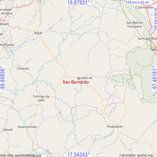
San Bernardo GPS coordinates[2]
18° 12' 45.36" North, 98° 6' 17.748" West
| Map corner | latitude | longitude |
|---|---|---|
| Upper-left | 18.87921°, | -98.80806° |
| Center: | 18.2126°, | -98.10493° |
| Lower-right: | 17.54343°, | -97.40181° |
| Map W x H: | 148.5×148.5 km | = 92.3×92.3mi |
| max Lat: | 32.7° ⇑76.1% North |
| San Bernardo: | 18.2126° |
| min Lat: | ⇓23.9% South 14.53588° |
| min Long | San Bernardo | max Long |
| -117.105° | -98.10493° | -86.73105° |
| W 62.4%⇐ | ⇒37.6% E |
Elevation
Elevation of San Bernardo is 1292 m = 4239 ft, and this is 38.3 m = 126 ft above average elevation for this country.
| Max E: |
3497 m = 11473 ft | 52.9% |
| San Bernardo | 1292 m 4239 ft | |
| Avg. | 1253.7 m = 4113 ft | |
Min E: |
-1 m = -3 ft | 47.1% |
See also: Mexico elevation on elevation.city.
Geographical zone
San Bernardo is located in North Torrid zone (between Equator and Tropic of Cancer). Distance of this Northern Tropic circle is 580.9 km =361 mi to North.| Distance of | km | miles | from San Bernardo |
|---|---|---|---|
| North Pole | 7982 | 4959.8 | to North |
| Arctic Circle | 5376.1 | 3340.6 | to North |
| Tropic Cancer | 580.9 | 361 | to North |
| Equator | 2025.1 | 1258.3 | to South |


Nearby cities:
15 places around San Bernardo: (largest is in red/bold)
• Acatlán de Osorio
6.1 km =3.8 mi,  100°
100°
• Ahuehuetitla
12.1 km =7.5 mi,  270°
270°
• Amatitlán de Azueta
5 km =3.1 mi,  143°
143°
• Garzones (Santa Gertrudis)
10.8 km =6.7 mi,  47°
47°
• Hermenegildo Galeana
4.9 km =3 mi,  3°
3°
• La Huerta
10.9 km =6.8 mi,  63°
63°
• Las Nieves
7 km =4.3 mi,  117°
117°
• Mixquitlixco
8.7 km =5.4 mi,  163°
163°
• San Francisco Rancho Nuevo
7 km =4.3 mi,  41°
41°
• San Isidro Labrador
12.4 km =7.7 mi, 163°
• San Pablo Anicano
10.1 km =6.3 mi,  167°
167°
• San Pedro Yeloixtlahuacan
11 km =6.8 mi, 164°
• San Vicente Boquerón
9.1 km =5.7 mi,  34°
34°
• Tetelcingo
8.8 km =5.5 mi,  70°
70°
• Tianguistengo
10.4 km =6.5 mi, 63°
Sources, notices
• [Note1] Compared only with cities in Mexico existing in our database
• [Src1] Map data: © OpenStreetMap contributors (CC-BY-SA)
• [Src2] Other city data from geonames.org with taken over terms of usage.
• [Src3] Geographical zone / Annual Mean Temperature by Robert A. Rohde @ Wikipedia
