Tequesquitengo geodata
Tequesquitengo (Morelos) is a populated place; located in Mexico in America/Mexico_City (GMT-6) time zone. With population of 3,548 people, there are 2574 cities with bigger population in this country. Compared to other cities in Mexico, 71.3% of cities are located further ↑North; 53.8% of cities are located further →East and 61.1% of cities have higher elevation than Tequesquitengo. Note1


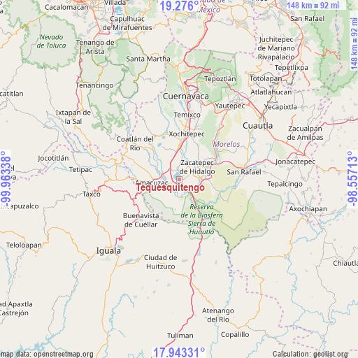
Tequesquitengo GPS coordinates[2]
18° 36' 39.456" North, 99° 15' 36.9" West
| Map corner | latitude | longitude |
|---|---|---|
| Upper-left | 19.276°, | -99.96338° |
| Center: | 18.61096°, | -99.26025° |
| Lower-right: | 17.94331°, | -98.55713° |
| Map W x H: | 148.2×148.2 km | = 92.1×92.1mi |
| max Lat: | 32.7° ⇑71.3% North |
| Tequesquitengo: | 18.61096° |
| min Lat: | ⇓28.7% South 14.53588° |
| min Long | Tequesquitengo | max Long |
| -117.105° | -99.26025° | -86.73105° |
| W 46.2%⇐ | ⇒53.8% E |
Elevation
Elevation of Tequesquitengo is 932 m = 3058 ft, and this is 321.7 m = 1055 ft below average elevation for this country.
| Max E: |
3497 m = 11473 ft | 61.1% |
| Avg. | 1253.7 m = 4113 ft | |
| Tequesquitengo | 932 m = 3058 ft | |
Min E: |
-1 m = -3 ft | 38.9% |
See also: Mexico elevation on elevation.city.
Geographical zone
Tequesquitengo is located in North Torrid zone (between Equator and Tropic of Cancer). Distance of this Northern Tropic circle is 536.6 km =333.4 mi to North.| Distance of | km | miles | from Tequesquitengo |
|---|---|---|---|
| North Pole | 7937.7 | 4932.3 | to North |
| Arctic Circle | 5331.8 | 3313 | to North |
| Tropic Cancer | 536.6 | 333.4 | to North |
| Equator | 2069.3 | 1285.8 | to South |


Nearby cities:
15 places around Tequesquitengo: (largest is in red/bold)
• 24 de Febrero
7.7 km =4.8 mi,  292°
292°
• Ampliación Nicolás Bravo
5.3 km =3.3 mi,  73°
73°
• El Coco
6 km =3.7 mi,  247°
247°
• El Estudiante
5.4 km =3.4 mi,  226°
226°
• Galeana
5.9 km =3.7 mi,  59°
59°
• Jicarero
3.9 km =2.4 mi,  83°
83°
• Jojutla
8.4 km =5.2 mi,  87°
87°
• Puente de Ixtla
6.1 km =3.8 mi,  273°
273°
• San Antonio Chiverías
6.1 km =3.8 mi,  41°
41°
• San José Vista Hermosa
4.9 km =3 mi,  352°
352°
• Tehuixtla
5.8 km =3.6 mi,  191°
191°
• Tlatenchi
8 km =5 mi,  101°
101°
• Unidad Habitacional José María Morelos y Pavón
4.5 km =2.8 mi, 76°
• Xoxocotla
8.3 km =5.2 mi,  10°
10°
• Zacatepec
8.8 km =5.5 mi, 57°
Sources, notices
• [Note1] Compared only with cities in Mexico existing in our database
• [Src1] Map data: © OpenStreetMap contributors (CC-BY-SA)
• [Src2] Other city data from geonames.org with taken over terms of usage.
• [Src3] Geographical zone / Annual Mean Temperature by Robert A. Rohde @ Wikipedia
