San José el Alto geodata
San José el Alto (Querétaro) is a populated place; located in Mexico in America/Mexico_City (GMT-6) time zone. With population of 14,094 people, there are 687 cities with bigger population in this country. Compared to other cities in Mexico, 71% of cities are located further ↓South; 68.2% of cities are located further →East and 75.3% of cities have lower elevation than San José el Alto. Note1


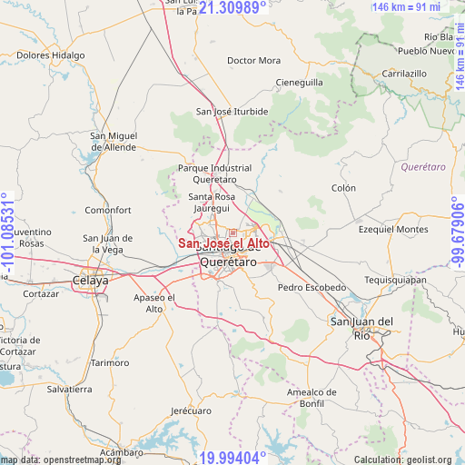
San José el Alto GPS coordinates[2]
20° 39' 12.204" North, 100° 22' 55.848" West
| Map corner | latitude | longitude |
|---|---|---|
| Upper-left | 21.30989°, | -101.08531° |
| Center: | 20.65339°, | -100.38218° |
| Lower-right: | 19.99404°, | -99.67906° |
| Map W x H: | 146.3×146.3 km | = 90.9×90.9mi |
| max Lat: | 32.7° ⇑29% North |
| San José el Alto: | 20.65339° |
| min Lat: | ⇓71% South 14.53588° |
| min Long | San José el Al | max Long |
| -117.105° | -100.38218° | -86.73105° |
| W 31.8%⇐ | ⇒68.2% E |
Elevation
Elevation of San José el Alto is 2036 m = 6680 ft, and this is 782.3 m = 2567 ft above average elevation for this country.
| Max E: |
3497 m = 11473 ft | 24.7% |
| San José el Alto | 2036 m 6680 ft | |
| Avg. | 1253.7 m = 4113 ft | |
Min E: |
-1 m = -3 ft | 75.3% |
See also: Mexico elevation on elevation.city.
Geographical zone
San José el Alto is located in North Torrid zone (between Equator and Tropic of Cancer). Distance of this Northern Tropic circle is 309.5 km =192.3 mi to North.| Distance of | km | miles | from San José el Alto |
|---|---|---|---|
| North Pole | 7710.6 | 4791.1 | to North |
| Arctic Circle | 5104.7 | 3171.9 | to North |
| Tropic Cancer | 309.5 | 192.3 | to North |
| Equator | 2296.4 | 1426.9 | to South |


Nearby cities:
15 places around San José el Alto: (largest is in red/bold)
• Bosques de la Hacienda
3.6 km =2.2 mi,  267°
267°
• Ejido San Pablo
3.5 km =2.2 mi,  292°
292°
• El Pozo
5.4 km =3.4 mi,  109°
109°
• El Salitre
4.5 km =2.8 mi, 288°
• Fray Junípero Serra [Fraccionamiento]
1.4 km =0.9 mi,  60°
60°
• La Cañada
7.2 km =4.5 mi,  134°
134°
• La Pradera
4.2 km =2.6 mi,  81°
81°
• La Purísima
4.3 km =2.7 mi, 128°
• Lomas de Menchaca
1.8 km =1.1 mi,  187°
187°
• Ninguno [CERESO]
3.2 km =2 mi,  45°
45°
• Paseos del Pedregal
2 km =1.2 mi,  305°
305°
• Rancho Largo
8.2 km =5.1 mi, 312°
• Santiago de Querétaro
7.3 km =4.5 mi,  184°
184°
• Sergio Villaseñor
4.1 km =2.5 mi,  256°
256°
• Villas Fontana [Fraccionamiento]
2.7 km =1.7 mi,  283°
283°
Sources, notices
• [Note1] Compared only with cities in Mexico existing in our database
• [Src1] Map data: © OpenStreetMap contributors (CC-BY-SA)
• [Src2] Other city data from geonames.org with taken over terms of usage.
• [Src3] Geographical zone / Annual Mean Temperature by Robert A. Rohde @ Wikipedia
