Santiago Jalahui geodata
Santiago Jalahui (Oaxaca) is a populated place; located in Mexico in America/Mexico_City (GMT-6) time zone. With population of 717 people, there are 12151 cities with bigger population in this country. Compared to other cities in Mexico, 83.6% of cities are located further ↑North; 82.7% of cities are located further ←West and 73.2% of cities have higher elevation than Santiago Jalahui. Note1


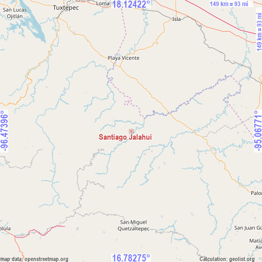
Santiago Jalahui GPS coordinates[2]
17° 27' 16.992" North, 95° 46' 14.988" West
| Map corner | latitude | longitude |
|---|---|---|
| Upper-left | 18.12422°, | -96.47396° |
| Center: | 17.45472°, | -95.77083° |
| Lower-right: | 16.78275°, | -95.06771° |
| Map W x H: | 149.2×149.2 km | = 92.7×92.7mi |
| max Lat: | 32.7° ⇑83.6% North |
| Santiago Jalahui: | 17.45472° |
| min Lat: | ⇓16.4% South 14.53588° |
| min Long | Santiago Jalahu | max Long |
| -117.105° | -95.77083° | -86.73105° |
| W 82.7%⇐ | ⇒17.3% E |
Elevation
Elevation of Santiago Jalahui is 281 m = 922 ft, and this is 972.7 m = 3191 ft below average elevation for this country.
| Max E: |
3497 m = 11473 ft | 73.2% |
| Avg. | 1253.7 m = 4113 ft | |
| Santiago Jalahui | 281 m = 922 ft | |
Min E: |
-1 m = -3 ft | 26.8% |
See also: Mexico elevation on elevation.city.
Geographical zone
Santiago Jalahui is located in North Torrid zone (between Equator and Tropic of Cancer). Distance of this Northern Tropic circle is 665.1 km =413.3 mi to North.| Distance of | km | miles | from Santiago Jalahui |
|---|---|---|---|
| North Pole | 8066.3 | 5012.2 | to North |
| Arctic Circle | 5460.4 | 3392.9 | to North |
| Tropic Cancer | 665.1 | 413.3 | to North |
| Equator | 1940.8 | 1206 | to South |


Nearby cities:
15 places around Santiago Jalahui: (largest is in red/bold)
• Arroyo Blanco
13.5 km =8.4 mi,  314°
314°
• Arroyo Colorado (Cruz Verde)
12.5 km =7.8 mi,  41°
41°
• Arroyo de Piedra
15.4 km =9.6 mi,  327°
327°
• Boca del Monte
18.3 km =11.4 mi,  13°
13°
• Ignacio Zaragoza
15.8 km =9.8 mi,  304°
304°
• La Esperanza
7.5 km =4.7 mi,  4°
4°
• Montenegro la Lana
18.3 km =11.4 mi, 326°
• Paso del Águila
17.3 km =10.7 mi,  54°
54°
• San Juan Jaltepec
16.1 km =10 mi,  134°
134°
• San Juan del Río
4.4 km =2.7 mi, 14°
• San Lorenzo
14.3 km =8.9 mi,  357°
357°
• Santiago Choápam
19.2 km =11.9 mi,  236°
236°
• Santiago Yaveo
15.3 km =9.5 mi,  150°
150°
• Santo Domingo Latani
16.6 km =10.3 mi, 236°
• Tatahuicapá
17.5 km =10.9 mi, 52°
Sources, notices
• [Note1] Compared only with cities in Mexico existing in our database
• [Src1] Map data: © OpenStreetMap contributors (CC-BY-SA)
• [Src2] Other city data from geonames.org with taken over terms of usage.
• [Src3] Geographical zone / Annual Mean Temperature by Robert A. Rohde @ Wikipedia
