Putaxcat geodata
Putaxcat (Puebla) is a populated place; located in Mexico in America/Mexico_City (GMT-6) time zone. With population of 890 people, there are 9797 cities with bigger population in this country. Compared to other cities in Mexico, 59% of cities are located further ↓South; 68.1% of cities are located further ←West and 68.5% of cities have higher elevation than Putaxcat. Note1


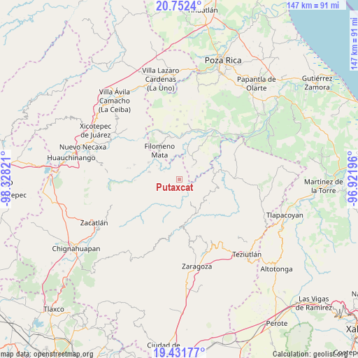
Putaxcat GPS coordinates[2]
20° 5' 36.528" North, 97° 37' 30.288" West
| Map corner | latitude | longitude |
|---|---|---|
| Upper-left | 20.7524°, | -98.32821° |
| Center: | 20.09348°, | -97.62508° |
| Lower-right: | 19.43177°, | -96.92196° |
| Map W x H: | 146.8×146.8 km | = 91.2×91.2mi |
| max Lat: | 32.7° ⇑41% North |
| Putaxcat: | 20.09348° |
| min Lat: | ⇓59% South 14.53588° |
| min Long | Putaxcat | max Long |
| -117.105° | -97.62508° | -86.73105° |
| W 68.1%⇐ | ⇒31.9% E |
Elevation
Elevation of Putaxcat is 499 m = 1637 ft, and this is 754.7 m = 2476 ft below average elevation for this country.
| Max E: |
3497 m = 11473 ft | 68.5% |
| Avg. | 1253.7 m = 4113 ft | |
| Putaxcat | 499 m = 1637 ft | |
Min E: |
-1 m = -3 ft | 31.5% |
See also: Mexico elevation on elevation.city.
Geographical zone
Putaxcat is located in North Torrid zone (between Equator and Tropic of Cancer). Distance of this Northern Tropic circle is 371.7 km =231 mi to North.| Distance of | km | miles | from Putaxcat |
|---|---|---|---|
| North Pole | 7772.9 | 4829.9 | to North |
| Arctic Circle | 5167 | 3210.6 | to North |
| Tropic Cancer | 371.7 | 231 | to North |
| Equator | 2234.2 | 1388.3 | to South |


Nearby cities:
15 places around Putaxcat: (largest is in red/bold)
• Acatzácatl
4.6 km =2.9 mi,  65°
65°
• Caxhuacán
3.8 km =2.4 mi,  150°
150°
• Chilocoyo del Carmen
3.5 km =2.2 mi,  244°
244°
• Cinco de Mayo
4.3 km =2.7 mi,  353°
353°
• Escatachuchut
4.4 km =2.7 mi,  196°
196°
• Francisco I. Madero
3.1 km =1.9 mi,  61°
61°
• Huehuetla
1.4 km =0.9 mi,  359°
359°
• Kuwik Chuchut
2.6 km =1.6 mi,  36°
36°
• Lacapan Camallagne
4.9 km =3 mi,  322°
322°
• Leacaman
2 km =1.2 mi,  286°
286°
• Lipuntahuaca
0.6 km =0.4 mi, 244°
• Ozelonacaxtla
5.3 km =3.3 mi,  167°
167°
• Pumacachocochuchut
3.4 km =2.1 mi, 317°
• Vicente Guerrero
4.5 km =2.8 mi, 317°
• Xonalpu
4.2 km =2.6 mi,  21°
21°
Sources, notices
• [Note1] Compared only with cities in Mexico existing in our database
• [Src1] Map data: © OpenStreetMap contributors (CC-BY-SA)
• [Src2] Other city data from geonames.org with taken over terms of usage.
• [Src3] Geographical zone / Annual Mean Temperature by Robert A. Rohde @ Wikipedia
