Leacaman geodata
Leacaman (Puebla) is a populated place; located in Mexico in America/Mexico_City (GMT-6) time zone. With population of 1,897 people, there are 4587 cities with bigger population in this country. Compared to other cities in Mexico, 59.1% of cities are located further ↓South; 68% of cities are located further ←West and 63.5% of cities have higher elevation than Leacaman. Note1


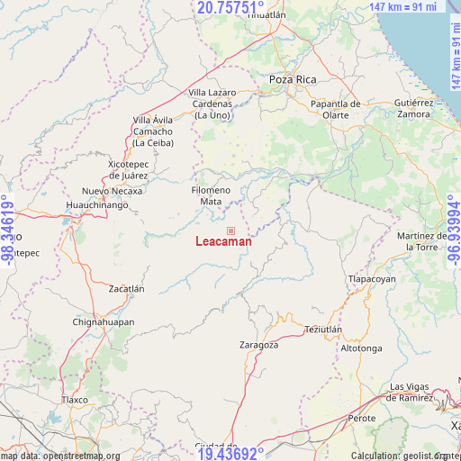
Leacaman GPS coordinates[2]
20° 5' 54.996" North, 97° 38' 35.016" West
| Map corner | latitude | longitude |
|---|---|---|
| Upper-left | 20.75751°, | -98.34619° |
| Center: | 20.09861°, | -97.64306° |
| Lower-right: | 19.43692°, | -96.93994° |
| Map W x H: | 146.8×146.8 km | = 91.2×91.2mi |
| max Lat: | 32.7° ⇑40.9% North |
| Leacaman: | 20.09861° |
| min Lat: | ⇓59.1% South 14.53588° |
| min Long | Leacaman | max Long |
| -117.105° | -97.64306° | -86.73105° |
| W 68%⇐ | ⇒32% E |
Elevation
Elevation of Leacaman is 787 m = 2582 ft, and this is 466.7 m = 1531 ft below average elevation for this country.
| Max E: |
3497 m = 11473 ft | 63.5% |
| Avg. | 1253.7 m = 4113 ft | |
| Leacaman | 787 m = 2582 ft | |
Min E: |
-1 m = -3 ft | 36.5% |
See also: Mexico elevation on elevation.city.
Geographical zone
Leacaman is located in North Torrid zone (between Equator and Tropic of Cancer). Distance of this Northern Tropic circle is 371.2 km =230.7 mi to North.| Distance of | km | miles | from Leacaman |
|---|---|---|---|
| North Pole | 7772.3 | 4829.5 | to North |
| Arctic Circle | 5166.4 | 3210.3 | to North |
| Tropic Cancer | 371.2 | 230.7 | to North |
| Equator | 2234.8 | 1388.6 | to South |


Nearby cities:
15 places around Leacaman: (largest is in red/bold)
• Caxhuacán
5.4 km =3.4 mi,  135°
135°
• Chilocoyo del Carmen
2.4 km =1.5 mi,  211°
211°
• Cinco de Mayo
3.9 km =2.4 mi,  20°
20°
• Escatachuchut
4.9 km =3 mi,  172°
172°
• Francisco I. Madero
4.6 km =2.9 mi,  78°
78°
• Huehuetla
2 km =1.2 mi,  66°
66°
• Kuwik Chuchut
3.7 km =2.3 mi, 65°
• Lacapan Camallagne
3.5 km =2.2 mi,  342°
342°
• Lipuntahuaca
1.6 km =1 mi,  121°
121°
• Olintla
4.3 km =2.7 mi,  274°
274°
• Pumacachocochuchut
2 km =1.2 mi,  347°
347°
• Putaxcat
2 km =1.2 mi,  106°
106°
• Santa Catarina
5.2 km =3.2 mi, 345°
• Vicente Guerrero
3 km =1.9 mi, 337°
• Xonalpu
4.7 km =2.9 mi,  45°
45°
Sources, notices
• [Note1] Compared only with cities in Mexico existing in our database
• [Src1] Map data: © OpenStreetMap contributors (CC-BY-SA)
• [Src2] Other city data from geonames.org with taken over terms of usage.
• [Src3] Geographical zone / Annual Mean Temperature by Robert A. Rohde @ Wikipedia
